Major eruption of Manam volcano, ash up to 20 km (65 000 feet) – Papua New Guinea
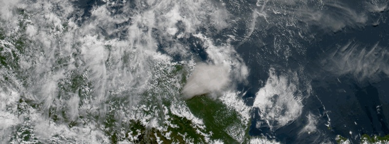
A major eruption occurred at Manam volcano, Papua New Guinea early on July 31, 2015. The Darwin VAAC reported volcanic ash plume reached 19.8 km (65 000 feet) at 02:00 UTC. Aviation color code is set on Red.
At 06:50 UTC, Darwin VAAC reporting volcanic ash was extending 370 km (230 miles) to the SW, but was dissipating.
Papua New Guinea's geohazards department said that the eruption has opened the vent's plumbing system and possible ongoing eruptions of variable magnitudes are possible.
The agency added it was unable to receive seismic data of the eruption due to technical problems with its transmission equipment, and details of the eruption's impacts are still unclear.
The town of Bogia has been coated in ash, and residents are being told to avoid venturing into the four main valleys.
More than 5 000 people living on the island are being evacuated to the Madang mainland.
Two injuries have been reported so far.
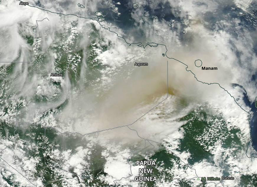
Image credit: NASA Aqua/MODIS. Acquired: July 31, 2015. Edit: The Watchers.
This is the first such eruption of this volcano since October 24, 2004. In November 2004, eruption of Manam volcano killed 5 people and forced more than 9 000 to evacuate.
- See JMA's Himawari-8 satellite animation loop showing the eruption of Manam volcano on July 31, 2015 here.
Geological summary
The 10-km-wide island of Manam, lying 13 km off the northern coast of mainland Papua New Guinea, is one of the country's most active volcanoes. Four large radial valleys extend from the unvegetated summit of the conical 1807-m-high basaltic-andesitic stratovolcano to its lower flanks. These "avalanche valleys" channel lava flows and pyroclastic avalanches that have sometimes reached the coast. Five small satellitic centers are located near the island's shoreline on the northern, southern, and western sides.
Two summit craters are present; both are active, although most historical eruptions have originated from the southern crater, concentrating eruptive products during much of the past century into the SE valley. Frequent historical eruptions, typically of mild-to-moderate scale, have been recorded since 1616. Occasional larger eruptions have produced pyroclastic flows and lava flows that reached flat-lying coastal areas and entered the sea, sometimes impacting populated areas.
Featured image: Manam eruption on July 31, 2015 as seen from space. Credit: JMA/Himawari-8.
Commenting rules and guidelines
We value the thoughts and opinions of our readers and welcome healthy discussions on our website. In order to maintain a respectful and positive community, we ask that all commenters follow these rules:
We reserve the right to remove any comments that violate these rules. By commenting on our website, you agree to abide by these guidelines. Thank you for helping to create a positive and welcoming environment for all.