Soudelor rapidly intensifies into a super typhoon, becomes the strongest cyclone of 2015 – moving toward Taiwan and eastern China

Tropical Storm "Soudelor" formed on July 31, 2015 northeast of Chuuk, North Pacific Ocean. It reached typhoon strength on August 2 and passed directly over Saipan, causing severe damage to the island. On August 3, Soudelor became a Super Typhoon.
This system is expected to further intensify and peak at about 296 km/h (184 mph) on August 4. It will then gradually weaken as it approaches Taiwan and makes final landfall over eastern China on August 8 (UTC). Both countries are in for some very serious weather conditions in terms of high wind and heavy rainfall.
Soudelor's center passed directly over Saipan, Mariana Islands (population 48 000) on August 2 with wind gusts of about 146 km/h (91 mph) – upper edge of Category 1 equivalent storm on the Saffir Simpson hurricane wind scale.
It downed power poles, removed roofs off buildings and flooded Saipan's power plant. As of press time (late August 3, UTC) no serious injuries or casualties have been reported. A state of disaster and significant emergency was declared by Acting Governor Ralph DLG Torres.

At 15:00 UTC on August 3, Soudelor's maximum sustained winds increased to 250 km/h (155.4 mph). Typhoon-force winds were compact, extending 48 km (30 miles) from the center. At the time, the storm was centered about 496.3 km (308 miles) WNW Saipan. It was moving to the WNW at 22.2 km/h (13.8 mph).
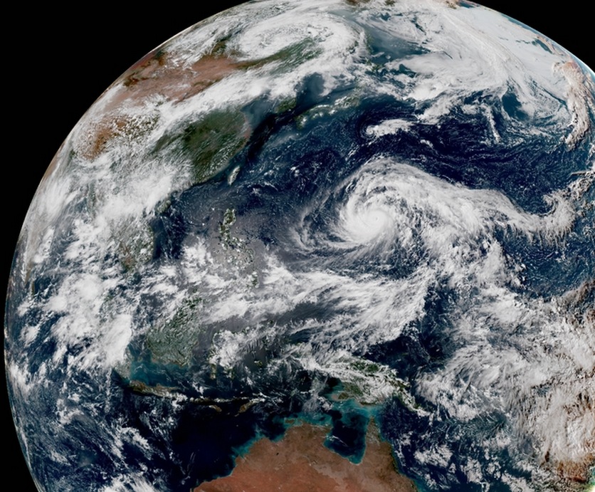
Typhoon "Soudelor" on August 3, 2015 at 05:30 UTC. Credit: JMA/RAMMB/CIRA (Himawari-8).
By 18:00 UTC, Soudelor further strengthened and reached maximum sustained winds of 287 km/h (178 mph), which made it the strongest cyclone of 2015, so far. It was located about 1 640 km (1 019 miles) from Okinawa, Japan.
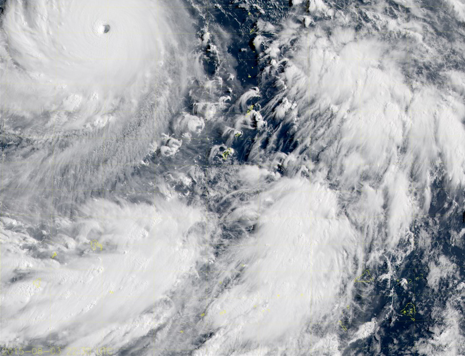
Super Typhoon "Soudelor" on August 3, 2015 at 22:30 UTC. Image credit: JMA/RAMMB/CIRA (Himawari-8).
Animated enhanced infrared satellite imagery shows the system has become more symmetric as it continued to deepen and wind tighter into a sharply outline 26 km (16 miles) wide eye, JTWC noted at 21:00 UTC today. Environmental conditions are expected to remain conductive for intensification, peaking at 296 km/h (184 mph) over the next 12 hours. After 36 hours, environmental conditions will become slightly less favorable leading to gradual weakening.
Super Typhoon "Soudelor" is expected to clip the northern coast of Taiwan late August 7 / early August 8 (UTC), before making a final landfall over eastern China on August 8.
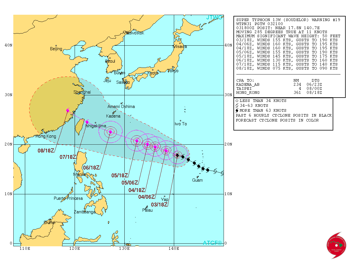
Super Typhoon "Soudelor" forecast track by JTWC on August 3, 2015. Image credit: JTWC/ATCF.
Satellite animations
- Storm-Centered Infrared (MTSAT2; NOAA/SSD)
- Storm-Centered Infrared (Aviation Color Enhancement) (MTSAT2; NOAA/SSD)
- Storm-Centered Water Vapor (MTSAT2; NOAA/SSD)
- Storm-Centered Visible (MTSAT2; NOAA/SSD)
- Storm-Centered Visible (Colorized) (MTSAT2; NOAA/SSD)
- Storm-Centered Infrared (MTSAT2; CIMSS)
- Storm-Centered Enhanced Infrared (MTSAT2; CIMSS)
- Storm-Centered Water Vapor (MTSAT2; CIMSS)
- Storm-Centered Visible (MTSAT2; CIMSS)
- Tropical West Pacific Infrared (MTSAT2; NOAA)
- Tropical West Pacific Enhanced Infrared (MTSAT2; NOAA)
- Tropical West Pacific Water Vapor (MTSAT2; NOAA)
- Tropical West Pacific Visible (MTSAT2; NOAA)
Featured image: Super Typhoon "Soudelor" on August 3, 2015 at 05:30 UTC. Credit: JMA/RAMMB/CIRA (Himawari-8).
Commenting rules and guidelines
We value the thoughts and opinions of our readers and welcome healthy discussions on our website. In order to maintain a respectful and positive community, we ask that all commenters follow these rules.