Powerful Typhoon “Soudelor” to make landfall over central Taiwan on August 7, 2015
Typhoon "Soudelor" made a direct hit to Saipan, Northern Mariana Islands on August 2, 2015 generating significant damage to the island. It became the strongest cyclone of the year on August 3, with wind speeds reaching 287 km/h (178 mph). The following day, Soudelor started a weakening phase and became a Category 2 equivalent storm on August 5, with wind speeds of 167 km/h (103 mph).
Late August 6 (UTC), conditions became favorable for another intensification phase and Soudelor started strengthening again. Forecasters expected it to make landfall over the central Taiwan late August 7 as a major typhoon (Category 4 equivalent), with maximum sustained winds near 212 km/h (132 mph).
Schools and businesses in eastern parts of Taiwan are closed. About 2 000 people have been evacuated from Taiwan’s outlying islands, popular with tourists. Taiwan Railways Administration canceled part of its service, and some domestic flights were also canceled. Tourists and local residents are ordered not to visit beaches on the island's east coast.
This powerful typhoon already claimed at least one life, when a young girl was swept out to sea in eastern Yilan county on Thursday, August 6.
Another child was also missing in the same incident, while a 38-year-old woman and another girl survived.
“The girl who died and the one who went missing were swept away by strong waves,” a spokesman for the National Fire Agency said.
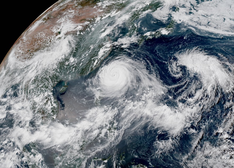
Typhoon "Soudelor" as it approached Taiwan early August 7, 2015. Image credit: JMA/RAMMB/CIRA (Himawari-8).
At 03:00 UTC on August 7, Typhoon "Soudelor" had maximum sustained winds of 194 km/h (120 mph) with wind gusts to 240 km/h (150 mph). The storm is intensifying and moving to the WNW at 18.5 km/h (11.5 mph). Maximum significant wave height is 10.7 meters (35 feet).
During the next 12 hours, Soudelor is forecast to intensify to 212 km/h (132 mph), JTWC noted.
After landfall, the system will weaken rapidly as it transits across the mountainous terrain and re-emerge over the Taiwan Strait as a weak typhoon.
Around 12:00 UTC on August 8, Soudelor will make its third landfall. This time over the eastern coast of China, near Quanzhou, with maximum sustained wind speeds near 148 km/h (92 mph) – Category 1 equivalent on the Saffir-Simpson Hurricane Wind Scale.
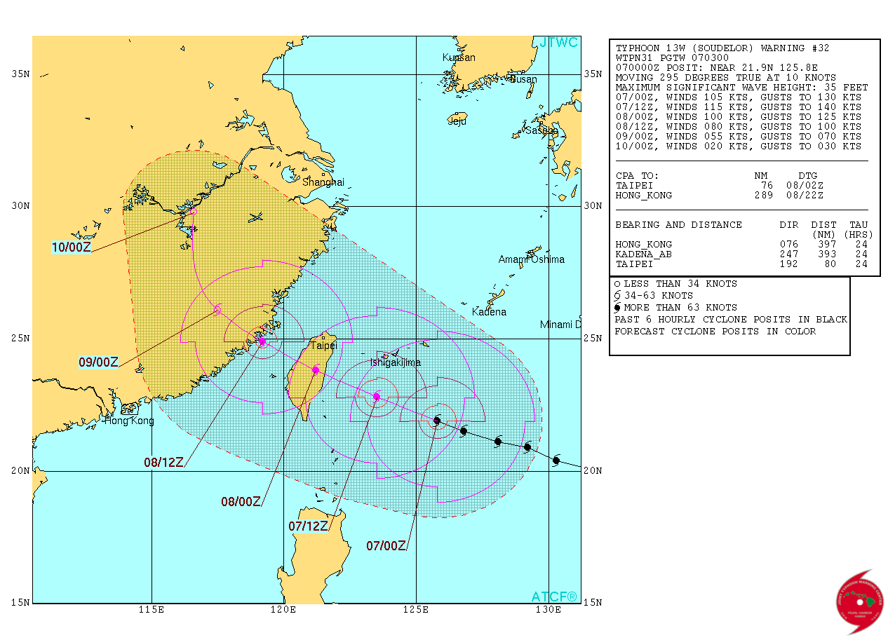
Typhoon "Soudelor" forecast track by JTWC on August 7, 2015. Image credit: JTWC/ACTF.
Soudelor will unleash heavy rains across northern and eastern Taiwan. The government warned all departments to take precautionary measures ahead of its landfall, including preparation for floods, landslides, and fallen trees.
The defence ministry said it had readied 100 shelters that can accommodate more than 45 000 people, while around 32 000 soldiers were placed on standby for disaster relief.
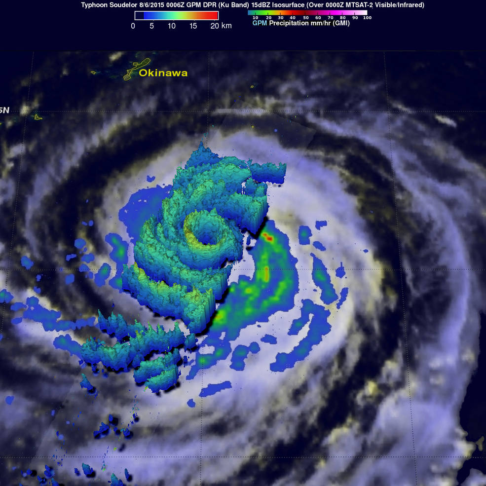
On August 6 at 00:06 UTC, GPM saw Typhoon Soudelor's heaviest rain a rate of close to 70 mm (2.4 inches) per hour in a strong thunderstorm band southwest of the center. Credits: NASA/JAXA, Hal Pierce.
Satellite animations
- Storm-Centered Infrared (MTSAT2; NOAA/SSD)
- Storm-Centered Infrared (Aviation Color Enhancement) (MTSAT2; NOAA/SSD)
- Storm-Centered Water Vapor (MTSAT2; NOAA/SSD)
- Storm-Centered Visible (MTSAT2; NOAA/SSD)
- Storm-Centered Visible (Colorized) (MTSAT2; NOAA/SSD)
- Storm-Centered Infrared (MTSAT2; CIMSS)
- Storm-Centered Enhanced Infrared (MTSAT2; CIMSS)
- Storm-Centered Water Vapor (MTSAT2; CIMSS)
- Storm-Centered Visible (MTSAT2; CIMSS)
- Tropical West Pacific Infrared (MTSAT2; NOAA)
- Tropical West Pacific Enhanced Infrared (MTSAT2; NOAA)
- Tropical West Pacific Water Vapor (MTSAT2; NOAA)
- Tropical West Pacific Visible (MTSAT2; NOAA)
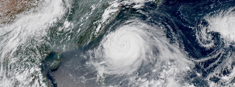
Featured image: Typhoon "Soudelor" on August 7, 2015. Credit: JMA/RAMMB/CIRA (Himawari-8).
Commenting rules and guidelines
We value the thoughts and opinions of our readers and welcome healthy discussions on our website. In order to maintain a respectful and positive community, we ask that all commenters follow these rules:
We reserve the right to remove any comments that violate these rules. By commenting on our website, you agree to abide by these guidelines. Thank you for helping to create a positive and welcoming environment for all.