Atsani becomes 6th super typhoon of the year, Goni threatens Philippines, Taiwan and southern Japan
Typhoon "Atsani" became the sixth super typhoon of the year on August 19, 2015. The system is currently moving over the open waters of North Pacific Ocean and is threatening only shipping interests. However, there is a threat it could impact Honshu, Japan late next week with destructive winds, heavy rainfall and mudslides. Meanwhile, Typhoon "Goni" is another powerful typhoon in the Pacific Ocean, currently threatening Philippines and Taiwan.
Latest forecast tracks don't see Goni making Taiwan landfall, as forecasted earlier. Instead, it is expected to turn toward southern Japan, and pass east of Taiwan over the next couple of days.
HWRF 2-km simulation — finest model grid we have — of Typhoons #Goni & #Atsani from their respective model "nests" pic.twitter.com/KVO4NEm0c3
— Ryan Maue (@RyanMaue) August 19, 2015
There are several warnings currently in effect in the Philippines. Public storm warning signal #2 is in effect in the Batanes Group of Islands and Cagayan including the Calayan and Babuyan Group of Islands. In addition, Public Storm Warning Signal #1 is in effect for Isabela, Kalinga, Apayao, Abra and Ilocos Norte.
PAGASA expects Goni to fall just short of reaching super typhoon strength.
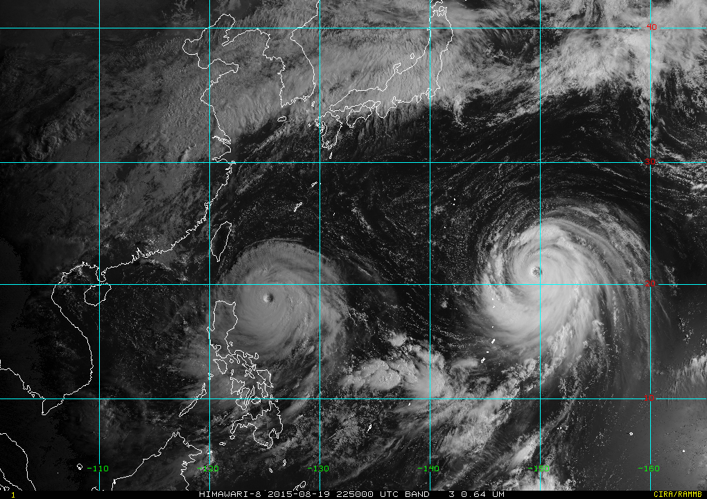
Typhoon "Goni" and Super Typhoon "Atsani" on August 19, 2015 at 22:50 UTC. Image credit: JMA/RAMMB/CIRA (Himawari-8).
Multiple tropical systems roaming the western Pacific is far from unusual… "What is uncommon is the fact that there could be two super typhoons at the same time," said AccuWeather Meteorologist Anthony Sagliani. The last time that occurred was October 1997 with Ivan and Joan.
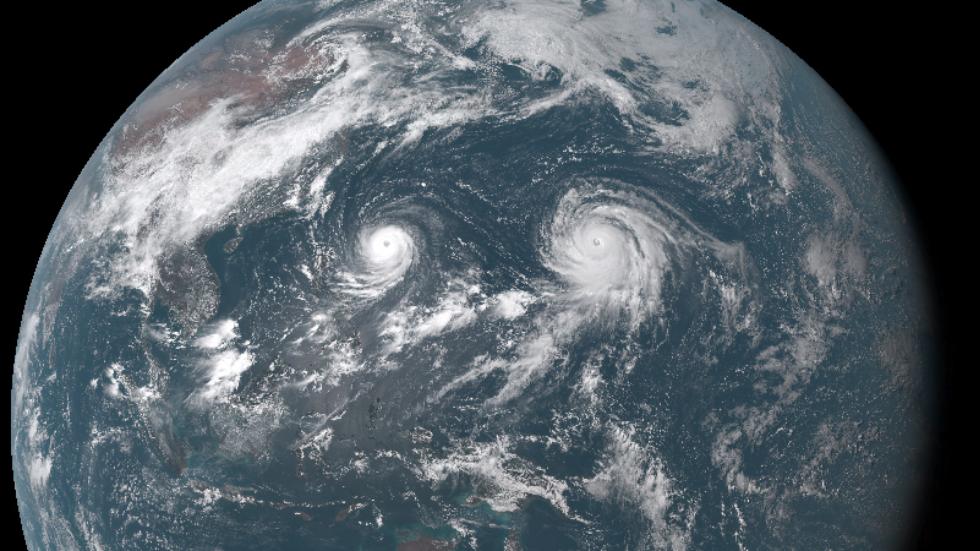
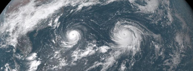
Typhoon "Goni" and Super Typhoon "Atsani" on August 19, 2015. Image credit: JMA/Himawari-8.
On August 19, 2015 at 15:00 UTC, Super Typhoon "Atsani" had maximum sustained winds near 259.3 km/h (161.1 mph), making it a Category 5 hurricane on the Saffir-Simpson Hurricane Wind Scale. It was centered about 1 180 km (733 miles) east-southeast of Iwo To island, Japan, and moving to the northwest at 12.9 km/h (8 mph).
Typhoon-force winds were occurring up to 55.5 km (34.5 miles) from the center, and tropical storm-force winds were occurring up to 333 km (207 miles) from the center, making the storm about 360 nautical miles (414 miles/666.7 km) wide, NASA's GSFC noted.
Animated enhanced infrared satellite imagery depicts a 92.6 km (57.5 miles) round eye with deep convection located primarily over the southern semi-circle, JTWC said. Their forecasters expect Atsani will intensify to 268.6 km/h (166.8 mph) by August 20 and then start weakening as it turns northeast, remaining well south of Japan.
.jpg)
Super Typhoon "Atsani" on August 19, 2015. Image credit: NASA Aqua/MODIS.
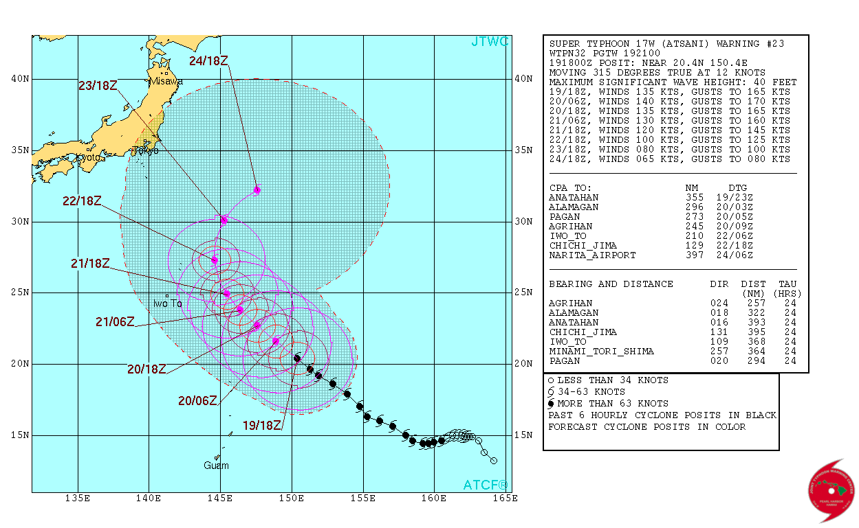
Super Typhoon "Atsani" forecast track by JTWC on August 19, 2015.
On August 19, 2015 at 15:00 UTC, Typhoon "Goni" had maximum sustained winds near 231.5 km/h (143.8 mph), making it a Category 4 hurricane on the Saffir-Simpson Scale. It was centered about 846.4 km (525.9 miles) south of Okinawa, Japan, and moving to the west at 25.9 km/h (16.1 mph).
JTWC expects Goni will pass to the north of Luzon, Philippines and start weakening on August 21 before turning sharply north to pass Taiwan to the east.
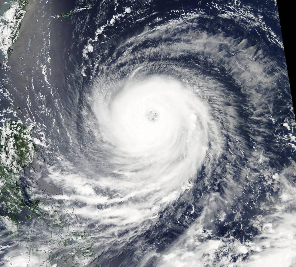
Typhoon "Goni" on August 19, 2015. Image credit: NASA Aqua/MODIS.
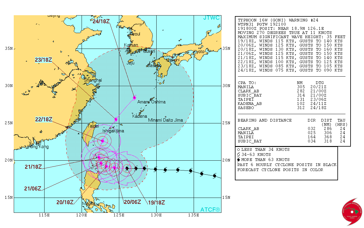
Typhoon "Goni" forecast track by JTWC on August 19, 2015.
The latest AccuWeather tropical forecast calls for nine super typhoons through the end of the year, which would stand as the third-highest total on record behind 1965 and 1997 with 11 super typhoons each year.
Featured image: Typhoon "Goni" and Super Typhoon "Atsani" on August 19, 2015. Credit: JMA/Himawari-8.
Commenting rules and guidelines
We value the thoughts and opinions of our readers and welcome healthy discussions on our website. In order to maintain a respectful and positive community, we ask that all commenters follow these rules:
We reserve the right to remove any comments that violate these rules. By commenting on our website, you agree to abide by these guidelines. Thank you for helping to create a positive and welcoming environment for all.