Hurricane “Jimena” becomes a major hurricane in the eastern Pacific
Hurricane "Jimena", a tenth named storm of the 2015 eastern Pacific hurricane season, has evolved into a major hurricane in only a couple of days, and although is currently located well of the mainland, its rapid intensification requires a careful observation.
The hurricane formed in the eastern Pacific as a Tropical Depression "Thirteen-E" on August 26, 2015. The system's intensity has rapidly increased in only a couple of days.
At 03:00 UTC on August 29, the center of Hurricane "Jimena" was located 1 115 km (1 190 miles) southwest of the southern tip of Baja California. It was moving toward the west near 19 km/h (12 mph), and this general motion is expected to continue for the next 12 to 24 hours, according to latest NHC forecast. A turn toward the west-northwest is expected by late Saturday.
Maximum sustained winds have rapidly increased to near 205 km/h (125 mph) with higher gusts. This makes Jimena a category 3 hurricane on the Saffir-Simpson Hurricane Wind Scale.
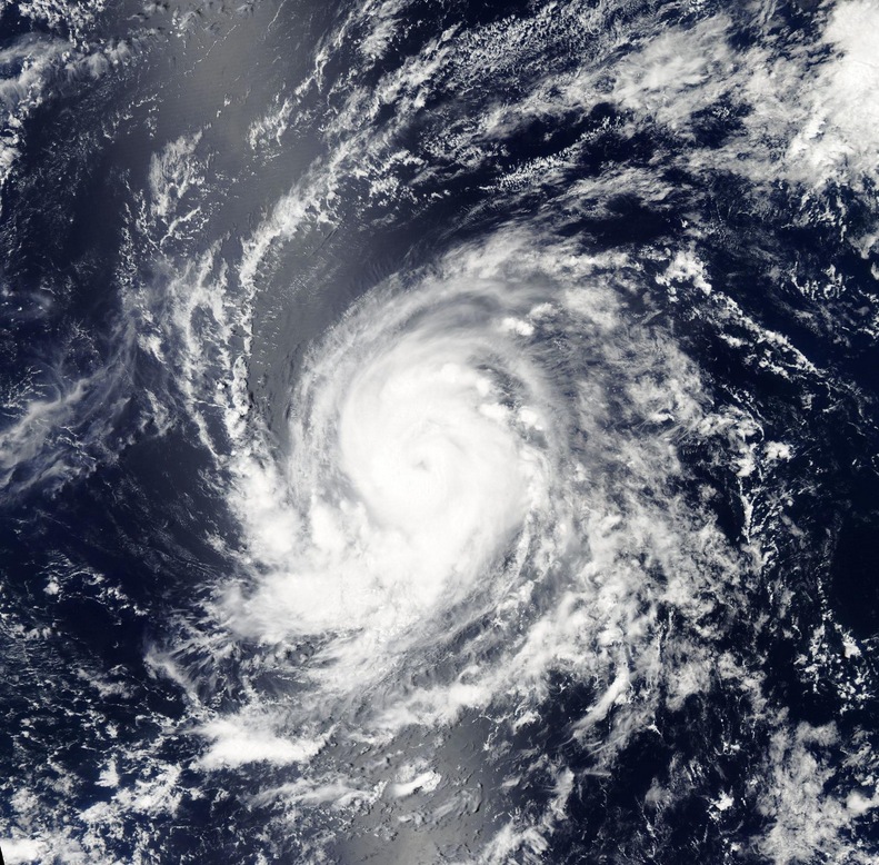
Hurricane "Jimena" on August 28, 2015. Image credit: NASA Aqua/MODIS.
NHC expects additional strengthening during the next 24 hours, and Jimena is expected to reach near category 5 strength today. After that time, fluctuations in intensity are possible, but Jimena should remain a powerful hurricane.
The estimated minimum central pressure is 957 hPa.
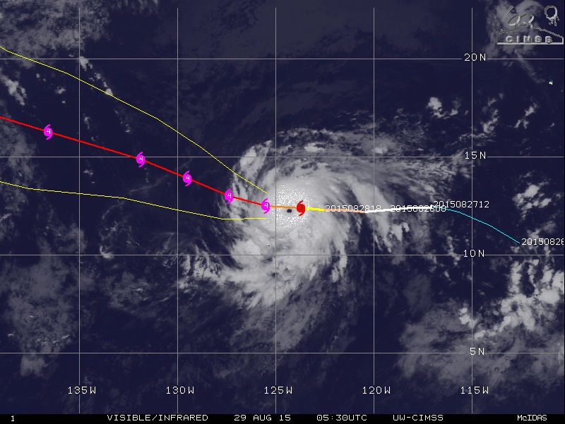
Hurricane "Jimena" track, August 28, 21:30 UTC. Image credit: UW-CIMSS
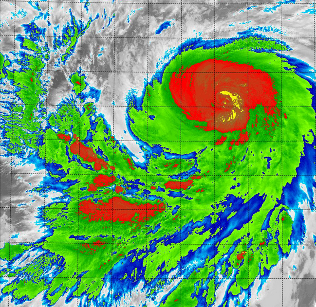
Infrared image of Hurricane "Jimena", August 28, 10:16 UTC. Image credit: NRL/NASA/NOAA
NASA-NOAA's Suomi NPP satellite flew over Hurricane "Jimena" at 10:16 UTC on August 28. The Visible Infrared Imaging Radiometer Suite (VIIRS) of the satellite has measured the cloud top temperatures below -53 ºC (-63 ºF), indicating a strong thunderstorm building up inside the hurricane's northern quadrant.
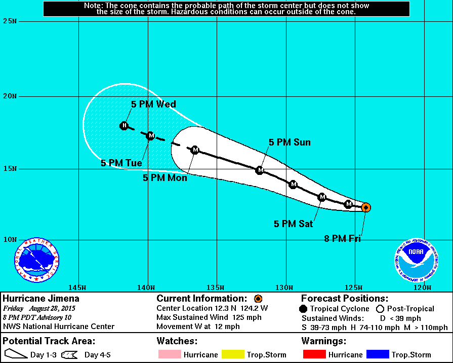
Hurricane "Jimena" 5-day track forecast. Image credit: NHC
After August 30, a slightly drier air mass environment and cooler ocean waters are expected to lead to its gradual weakening. The system isn't expected to make a landfall over the next few days, however, due to its robust development, meteorologists will continue to carefully track its movement.
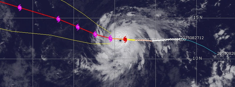
Featured image: Hurricane "Jimena" forecast track on August 29, 2015. Image credit: UW-CIMSS.
This Vedic astrology writer predicted in June 2015 ( submitted in April) in article -” Total lunar eclipse of 28 September 2015 and world” – published in Summer 2015 issue of The Astrologer’s Notebook, a quarterly print Newsletter from North Port, Florida as follows:
” Second half of 2015 seems to be causing concern. Dangers from sea or in sea like strong storms or tsunamies could be likely in vulnerable regions. Some islands located near sea may need to take some precaution”.
Could it not have served a hint to the concerned? It is for readers to ponder over and decide.