Tropical Storm “Henri” to bring heavy rainfall and strong winds to southeast Newfoundland, Canada
Tropical Depression "Eight" formed in the North Atlantic on September 9, 2015 and evolved into a Tropical Storm "Henri" around 03:00 UTC on September 10, National Hurricane Center (NHC) reported. Henri thus became the eight named storm of the 2015 Atlantic Ocean hurricane season. No coastal warnings have so far been put into effect, although some heavy rainfall and strong wind gusts might affect the southeast Newfoundland on September 12.
Tropical Storm "Henri" was located 370 km (230 miles) east-southeast of Bermuda at 09:00 UTC on September 10, 2015, according to NHC. The system was packing maximum sustained winds of 65 km/h (40 mph) and was moving northward at 6 km/h (3 mph). The minimum central pressure was estimated at 1008 hPa, while the tropical storm force winds extend up to 205 km (125 miles) east of the center.
Video credit: The Weather Network
Henri is expected to continue its general motion with an increase in forward speed through the evening of September 10 and then move north-northeastward on September 11, according to NHC forecast. Maximum sustained winds are expected to remain around 65 km/h (40 mph) over the next 48 hours with wind gust strength somewhat increasing.
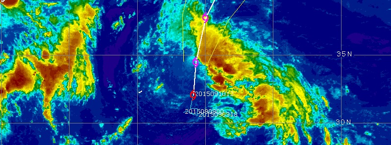
.png)
Tropical Storm "Henri" track, September 10, 12:45 UTC. Image credit: UW-CIMSS
West-southeasterly wind shear and dry air mass are currently affecting the system, however Henri is expected to gain some strength on the evening of September 10, following the shear lessening. Tropical storm is forecasted to pass the north wall of the Gulf Stream over the next 36 to 48 hours and enter an area of sharp gradient in sea surface temperature. Its motion will continue over cold water, and Henri is expected to lose tropical characteristics in the coming two days.
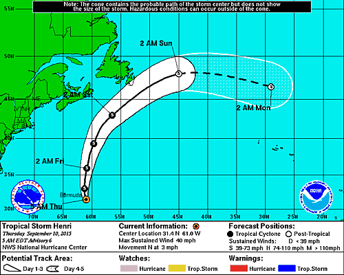
Tropical Storm "Henri" 5-day track forecast. Image credit: NHC
The center of the storm will pass east of Bermuda on September 10 and continue traveling toward Newfoundland as a post-tropical cyclone. Some heavy rainfall and strong wind gusts might impact the southeast Newfoundland in a quick pass-by on September 12.
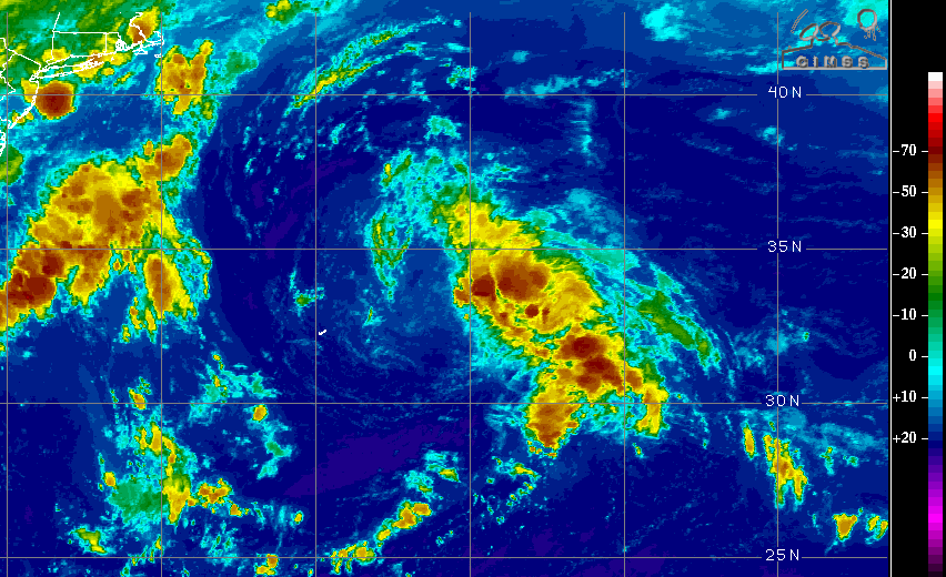
Image credit: UW-CIMSS
"At this stage it looks like this will be primarily be a marine system moving south of Atlantic Canada. Closest approach to land will be the Avalon Peninsula of Newfoundland. Henri may briefly make landfall on Saturday before racing east into the Atlantic,", The Canadian Hurricane Centre (CHC) announced.
No coastal watches or warnings were in effect, as of September 10.
Featured image: Tropical Storm "Henri", September 10, 12:45 UTC. Image credit: UW-CIMSS
Commenting rules and guidelines
We value the thoughts and opinions of our readers and welcome healthy discussions on our website. In order to maintain a respectful and positive community, we ask that all commenters follow these rules:
We reserve the right to remove any comments that violate these rules. By commenting on our website, you agree to abide by these guidelines. Thank you for helping to create a positive and welcoming environment for all.