Major Hurricane “Olaf” forecast to bring life-threatening surfs to Hawai’i and heavy rainfalls across Central America
Hurricane "Olaf" developed over the waters of central Pacific on October 19, 2015, and reached category 4 status by October 20, according to Central Pacific Hurricane Center (CPHC). Despite not making a direct landfall, large swells and rip currents could pose serious threat to the Hawai'i, while associated low pressure field, rich in moisture, could bring heavy rainfalls to Central America, Mexico and Texas over the coming days.
Olaf developed from a tropical depression "19-E" on October 15, according to the National Hurricane Center (NHC). By October 17, 03:00 UTC depression evolved into a tropical storm, which became a full blown hurricane by October 19, 03:00 UTC.
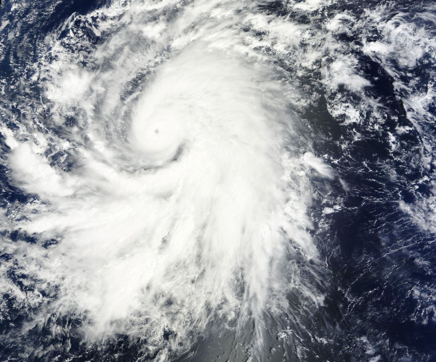
Hurricane "Olaf" synoptic situation, October 19, 2015. Image credit: NASA/Terra MODIS
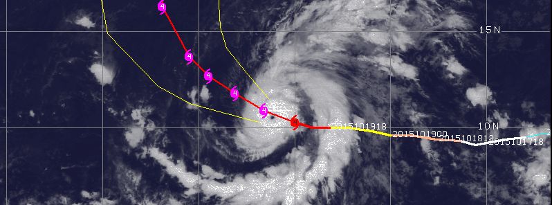
Hurricane "Olaf" was located 1 890 km east-southeast of Hilo, Hawai'i on October 20, 2015 at 09:00 UTC, according to Central CPHC, and was moving west-northwestward at 17 km/h (10 mph). The maximum sustained wind speeds of the system reached 240 km/h (150 mph) at the time, placing the system in a major category 4 hurricane. Its minimum central pressure was estimated at 938 hPa.
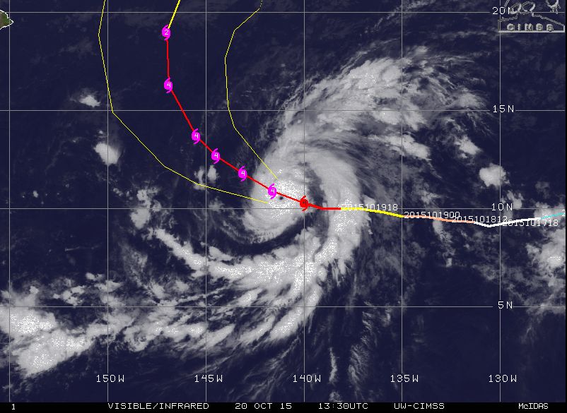
Hurricane "Olaf" movement track, October 20, 2015, 13:30 UTC. Image credit: UW-CIMSS
Hurricane force winds extend up to 55 km (34.2 miles) from its center, while tropical storm winds extend up to 220 km (136.7 miles) outwards.

A 35 second animation of infrared and visible imagery from NOAA's GOES-West satellite from Oct. 16-19, 2015, shows Hurricane Olaf strengthen into a major hurricane and develop an eye. Image credit: NASA/NOAA GOES project
According to the CPHC forecast, Olaf will continue traveling on its course before turning west-northwestward during October 20, then make another turn toward the northwest by October 21.
The hurricane is expected to slightly intensify during October 20, and fluctuate in strength over the coming days.
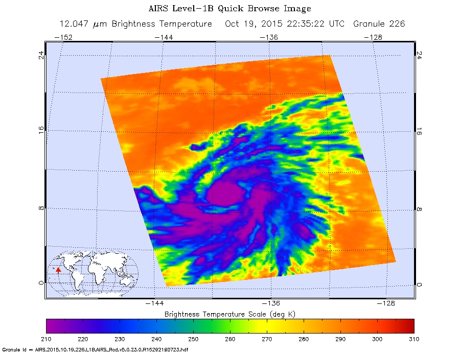
The AIRS instrument aboard NASA's Aqua satellite saw Olaf's cloud top temperatures exceeded -53 °C(-63 °F) (purple coloring) which indicates powerful storms with the heavy rainfall, October 19, 2015, 22:35 UTC. Image credit: NASA's JPL, Ed Olsen
Although meteorologists agree the hurricane will remain on a safe distance from the Hawai'i Islands, it could still prove to be dangerous to local residents, as it will generate large swells which will begin to affect the island shores over the next few days. Resulting surf waves and potential rip currents could create dangerous life-threatening conditions across Hawai'ian shores.
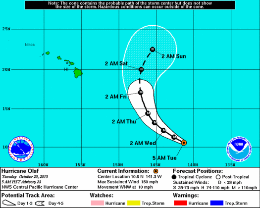
Hurricane "Olaf" 5-day forecast track. Image credit: NWS/NOAA
A wide cloudy patch of thunderstorm bands in the low-pressure area, associated with this hurricane, is currently extending over Central America and into the Pacific. This system will likely strengthen during October 20 and bring heavy rainfall over parts of Central America, Mexico and Texas by the end of this week, according to AccuWeather's meteorologists.
Featured image: Hurricane "Olaf" moving track, October 20, 2015, 13:30 UTC. Image credit: UW-CIMSS
Commenting rules and guidelines
We value the thoughts and opinions of our readers and welcome healthy discussions on our website. In order to maintain a respectful and positive community, we ask that all commenters follow these rules:
We reserve the right to remove any comments that violate these rules. By commenting on our website, you agree to abide by these guidelines. Thank you for helping to create a positive and welcoming environment for all.