Extremely Severe Cyclonic Storm “Chapala” to make landfall over central Yemen by November 2
Chapala, now an extremely severe cyclonic storm, equivalent to a category 4 hurricane, is steadily approaching Yemen. The system's strength is currently decreasing, however it is still expected to make landfall over central Yemen with hurricane force by November 2, 2015, according to the Joint Typhoon Warning Center (JTWC). Residents of eastern Yemen and parts of southwest Oman should remain highly alert and closely follow the news as the storm approaches.
Tropical Cyclone "Chapala" developed in the Arabian Sea on October 28, and rapidly intensified into a system of hurricane strength by October 29. The maximum sustained wind speeds of the system were near 240.8 km/h (149.6 mph) on October 30 at 15:00 UTC, which placed it into a super cyclonic storm class, equivalent to category 5 hurricane.
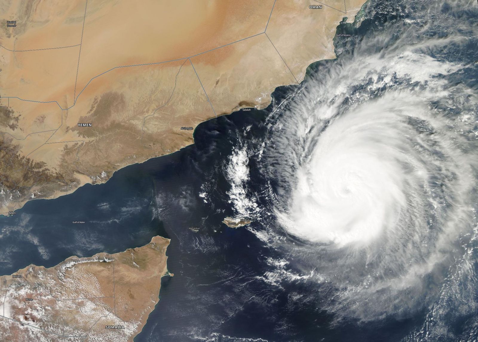
Tropical Cyclone "Chapala" approaching the coasts of Yemen and Oman, October 31, 2015. Image credit: NASA/ Aqua MODIS
According to meteorologist Eric Holthaus, tropical cyclones near the Arabian Peninsula are a very rare occurrence. Only two storms of hurricane strength have been recorded to make landfall in Oman, and only one storm of tropical strength hit Yemen. All of them happened after 2007.

Tropical Cyclone "Chapala" approaching Yemen and Oman animation. Video credit: Meteo Group France
Tropical Cyclone "Chapala" was located 387 km (246.7 miles) east-northeast of Socotra island, Yemen and was traveling westward at 14.8 km/h (9.19 mph) on October 31, at 15:00 UTC, according to JTWC. The system was packing maximum sustained winds of 213 km/h (132.4 mph) with gusts reaching 259.3 km/h (161.1 mph) and its central pressure was estimate at 937 hPa.
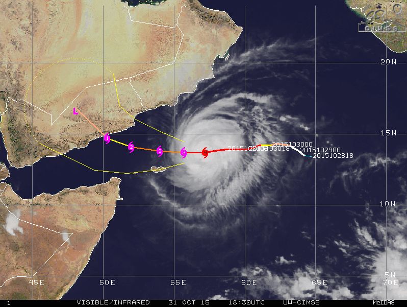
Tropical Cyclone "Chapala" track of motion, October 31, 18:30 UTC. Image credit: UW-CIMSS
The cyclone is currently tracking along the southern periphery of a deep layered sub-tropical ridge and is expected to make landfall over central Yemen in the next 48 hour, JTWC reports. Chapala, now an extremely severe cyclonic storm, equivalent to category 4 hurricane, is expected to further weaken while it approaches the Arabian Peninsula, due to the contact with dry air emanating from the land.
Despite undergoing weakening, Chapala will most likely hit the land with hurricane force winds, before dissipating due to interaction with the rugged and dry terrain prevailing across Yemen.

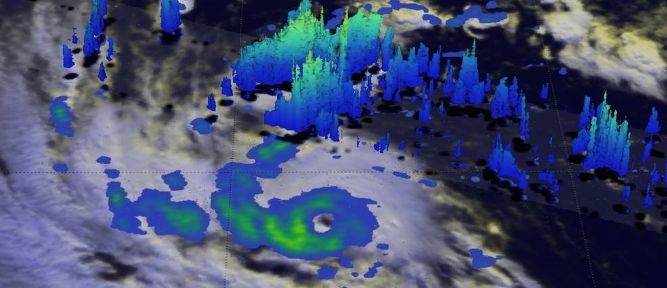
GPM 3-D image of rainfall and cloud heights of Chapala on October 28 found rainfall near the center of about 28 mm (1.1 inches) per hour and up to 64 mm (2.5 inches) per hour east of center. Image credit: NASA/JAXA/SSAI, Hal Pierce
Over the next three days, maximum sustained wind speeds are expected to drop to 55.6 km/h (34.5 mph) with gusts of about 74 km/h (46 mph), according to JTWC.
The system is expected to bring severe rainfall, hurricane force winds and coastal flooding to areas within 50 km (30 miles) of the center's landfall. Eastern Yemen and parts of southwest Oman could, on average, receive between 100 and 200 mm (4 to 8 inches) of rainfall, an amount capable of inducing life-threatening flooding across the affected parts.
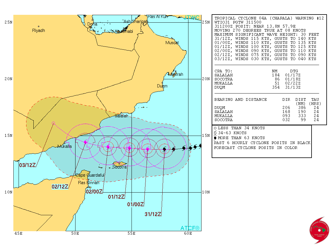
Tropical Cyclone "Chapala" 3-day forecast track. Image credit: JTWC
Areas of Yemen that should expect the strongest wind blow include Sayhut, Itab, Qishn, Hasway, Nishtun and Al Ghaydah
Meteorologists warn that residents of the forementioned areas should be placed on high alert, and closely monitor the situation as the system approaches.
Featured image: GPM 3-D image of rainfall and cloud heights of Chapala on October 28 found rainfall near the center of about 28 mm (1.1 inches) per hour and up to 64 mm (2.5 inches) per hour east of center. Image credit: NASA/JAXA/SSAI, Hal Pierce
90 percent of the world’s glaciers are growing!
NASA admits Antarctic Ice Sheet is growing
A new NASA study, released on Friday, admits that ice is accumulating in Antarctica.Satellite measurements show an 82-112 gigaton-a-year net ice gain. That’s 82-112 billion tons per year! Nine zeroes! 112,000,000,000 tons. Per year.It’s hard to comprehend how much ice that really is, so let’s put it in perspective.Let’s assume that they’re talking short tons (2,000 lbs). That’s about the weight of an old VW Beetle.Those old Beetles measured 14 feet long. Multiply 112 billion by 14 feet and you get 1,560 billion feet. Divide that by the distance from the earth to the moon (239,000 miles), and you’d have a string of VW Beetles stretching all the way to the moon.Not once, not twice, but 45 times. All the way to the moon.That’s a helluva lot of new ice. Every single year. And we’re worried about global warming?Not only is the Antarctic Ice Sheet growing, NASA admits that the growth is actually reducing sea-level rise. This also confirms what I’ve been saying all along.Antarctica contains 90 percent of the earth’s ice. If the Antarctic Ice Sheet is growing, wouldn’t that mean that more than 90 percent of the world’s glaciers are growing?_________________________________________________________________________Here are excerpts, taken from NASA’s own website:
“NASA – Antarctic Ice Sheet is Growing”
A new NASA study says that an increase in Antarctic snow accumulation that began 10,000 years ago is currently adding enough ice to the continent to outweigh the increased losses from its thinning glaciers.The research challenges the conclusions of other studies, including the Intergovernmental Panel on Climate Change’s (IPCC) 2013 report, which says that Antarctica is overall losing land ice.According to the new analysis of satellite data, the Antarctic ice sheet showed a net gain of 112 billion tons of ice a year from 1992 to 2001. That net gain slowed to 82 billion tons of ice per year between 2003 and 2008.“We’re essentially in agreement with other studies that show an increase in ice discharge in the Antarctic Peninsula and the Thwaites and Pine Island region of West Antarctica,” said Jay Zwally, a glaciologist with NASA Goddard Space Flight Center in Greenbelt, Maryland, and lead author of the study, which was published on Oct. 30 in the Journal of Glaciology. “Our main disagreement is for East Antarctica and the interior of West Antarctica – there, we see an ice gain that exceeds the losses in the other areas.” Zwally added that his team “measured small height changes over large areas, as well as the large changes observed over smaller areas.”Scientists calculate how much the ice sheet is growing or shrinking from the changes in surface height that are measured by the satellite altimeters. In locations where the amount of new snowfall accumulating on an ice sheet is not equal to the ice flow downward and outward to the ocean, the surface height changes and the ice-sheet mass grows or shrinks.The study analyzed changes in the surface height of the Antarctic ice sheet measured by radar altimeters on two European Space Agency European Remote Sensing (ERS) satellites, spanning from 1992 to 2001, and by the laser altimeter on NASA’s Ice, Cloud, and land Elevation Satellite (ICESat) from 2003 to 2008.They also used information on snow accumulation for tens of thousands of years, derived by other scientists from ice cores, to conclude that East Antarctica has been thickening for a very long time.The extra snowfall that began 10,000 years ago has been slowly accumulating on the ice sheet and compacting into solid ice over millennia, thickening the ice in East Antarctica and the interior of West Antarctica by an average of 0.7 inches (1.7 centimeters) per year.“The good news is that Antarctica is not currently contributing to sea level rise, but is taking 0.23 millimeters per year away,” Zwally said.See entire NASA article:
https://www.nasa.gov/feature/goddard/nasa-study-mass-gains-of-antarctic-ice-sheet-greater-than-losses
This should be your top story! Are you really watching out for us!