Hurricane “Sandra” threatens Mexico with heavy rainfall
Sandra developed over the warm eastern Pacific waters on November 24, 2015 and quickly intensified into a hurricane. The system is now a major Category 4 hurricane, about 800 km southwest of Mexico and moving northwards. The hurricane poses no threat to the mainland at the moment, however the states of Nayarit, Jalisco, Colima, Michoacan, Guerrero and the islands of the Revillagigedo Archipelago could receive large amounts of rainfall over the next 24 hours.
Tropical Storm "Sandra" formed on November 24 and intensified into a hurricane on November 25. Sandra has continued to intensify and is now a Category 4 hurricane system, thus becoming the season's latest major hurricane on record.
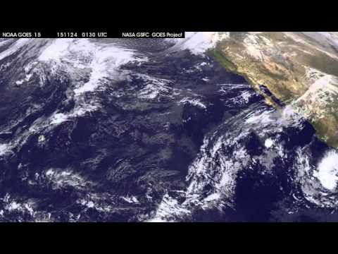
This 33 second animation of infrared and visible imagery from NOAA's GOES-West satellite in the period between November 23 and 25 shows Post-tropical Storm Rick fading west of Baja California, while Hurricane Sandra moves up along the west-central Mexican coast on November 24 and 25. Image credit: NASA/NOAA GOES Project
Hurricane "Sandra" was located about 810 km (500 miles) southwest of Cabo Corrientes Mexico and 925 km (575 miles) south of the southern tip of Baja California and moving north at 19 km/h (12mph), on November 26, 09:00 UTC, according to NHC. Maximum sustained winds were estimated at 230 km/h (145 mph) with gusts reaching 277.8 km/h (172.6 mph). Minimum central pressure of the system was 935 hPa at the time.
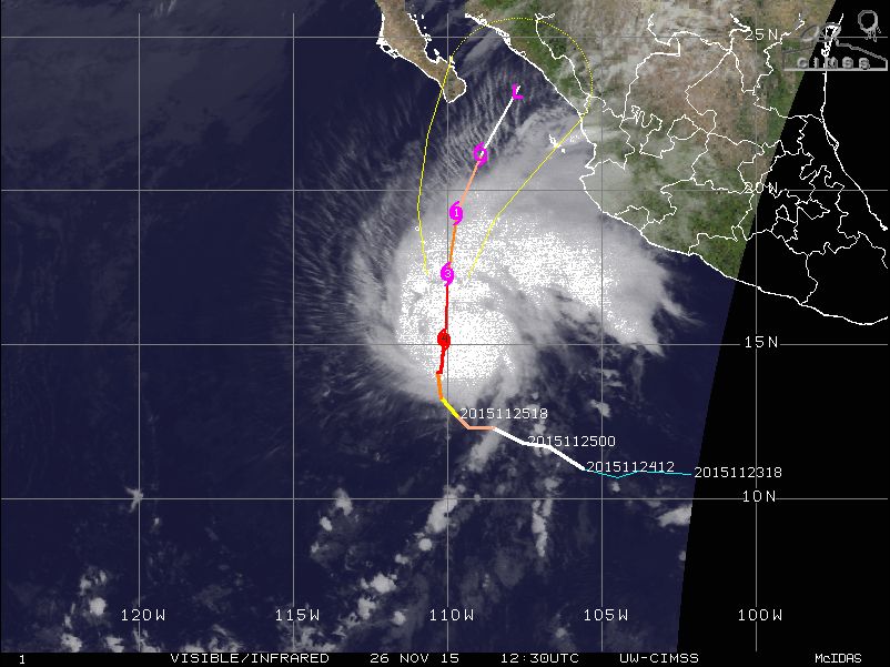
Hurricane "Sandra" off the coast of Mexico, November 26, 2015, 12:30 UTC. Image credit: UW-CIMSS
Winds of hurricane force extend up to 55 km (35 miles) from Sandra's center, and tropical storm force winds currently extend up to 185 km (115 miles) outward.
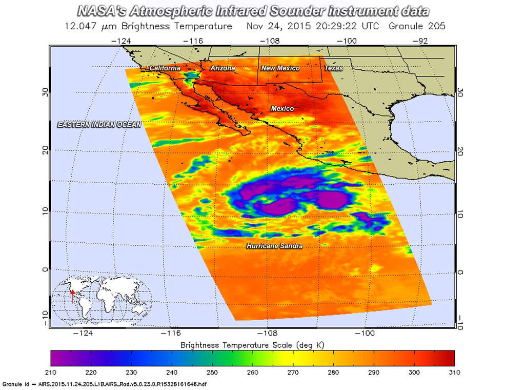
NASA's Aqua satellite captured infrared data on Tropical Storm Sandra as it was strengthening on November 24. Purple indicates cloud top temperatures near -53 °C (-63 °F) and powerful thunderstorms. Image credit: NASA JPL, Ed Olsen
Sandra is expected to turn toward north-northeast on November 27 and its center could pass near Socorro Island by the morning of November 27.

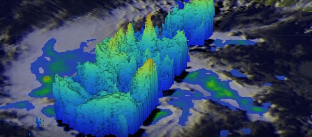
GPM saw intense convective storms south of the tropical storm's center of circulation were dropping rain at a rate of over 80 mm (3.1 inches) per hour. Cloud tops reached heights above 16 km (9.9 miles), November 24. Image credit: SSAI/NASA/JAXA, Hal Pierce
The system is expected to weaken to a storm strength over the next 48 hours, as its center passes south of the southern portion of the Baja California. In the next 3 days Sandra is forecast to dissipate to a remnant low over Mexico's mainland, according to NHC.
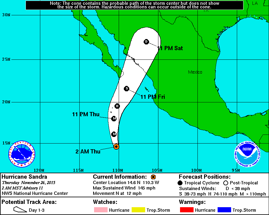
Hurricane "Sandra" 3-day forecast track. Image credit: NWS/NOAA
No coastal watches or warnings have been in effect so far, however, residents of the southern portions of the Baja California Peninsula are encouraged to monitor hurricane's progress, as portions of the area may require tropical storm or hurricane watches by the end of the day. Over the next 24 hour heavy rainfall could affect the states of Nayarit, Jalisco, Colima, Michoacan, Guerrero and the islands of the Revillagigedo Archipelago.
Featured image: GPM saw intense convective storms south of the tropical storm's center of circulation were dropping rain at a rate of over 80 mm (3.1 inches) per hour. Cloud tops reached heights above 16 km (9.9 miles), November 24, 2015. Image credit: SSAI/NASA/JAXA, Hal Pierce
Commenting rules and guidelines
We value the thoughts and opinions of our readers and welcome healthy discussions on our website. In order to maintain a respectful and positive community, we ask that all commenters follow these rules:
We reserve the right to remove any comments that violate these rules. By commenting on our website, you agree to abide by these guidelines. Thank you for helping to create a positive and welcoming environment for all.