A plume of deep moisture brings heavy flooding and landslides across the Pacific Northwest
Heavy rainfalls and strong winds battered the Pacific Northwest during December 7 and 8, 2015, triggering flooding and landslides across the area. A few areas have seen record amount of precipitation, according to the National Weather Service (NWS) and the occurrence was referred to as "extraordinary rainfall event" by Dylan River, a spokesman for Portland's Bureau of Transportation.
A system of Pacific storms began affecting the region during last week, and is set to continue lashing the Pacific Northwest with abundant amounts of rainfall. A strong jet stream stretching from eastern Asia across the Pacific Ocean serves to bring huge amounts of moisture to the region. This plume of moisture extends all the way into the western Pacific Ocean near the Philippines, and is being supplied by the so-called atmospheric river, a long, narrow plume of piping deep moisture, extending from the tropics into the mid-latitudes, meteorologists explained.
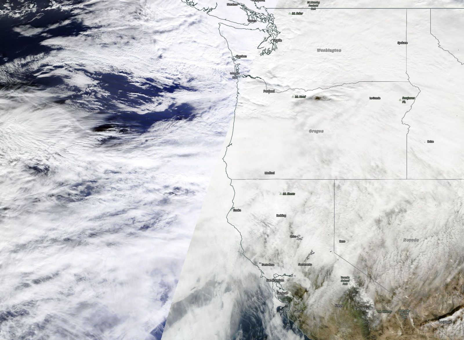
Synoptic situation over Washington, Oregon and parts of California, responsible for heavy rainfalls, December 7, 2015. Image credit: NASA/Terra MODIS
Torrential downpours have soaked the grounds of northern Oregon and southern Washington, following the strong wildfire season across the West.
81.3 mm (3.2 inches) of precipitation were measured in Portland in a 24 hour period between December 6 and 7, setting a new 24 hour rainfall accumulation record. For comparison, an average month of December in Portland usually records about 139.7 mm (5.5 inches) in total.
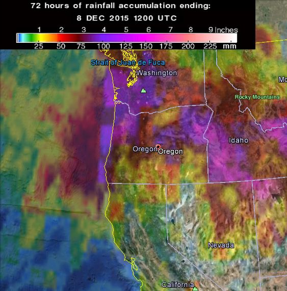
72-hr rainfall accumulation as observed by GPM Core Observatory. Image credit: NASA/JAXA GPM
A total of about 190.5 mm (7.5 inches) was observed in the vicinity of Lees Camp in northwestern Oregon, while Falls City reported 154.2 mm (6 inches) of precipitation. 27.4 mm (1.08 inches) of rain was observed at The Seattle-Tacoma International Airport, also setting a new day record for December 7.
Since the beginning of the rainstorm, 290.6 mm (11.44 inches) was reported in Humptulips, near the Olympic Mountains, as of December 8.
Video credit: NBC News
Wind gusts reaching 148 km/h (92 mph) were observed at Marys Peak, in west central Oregon on the morning of December 7 (local time) while 227 km/h (141 mph) was reported at Mount Hood in the afternoon.
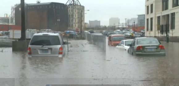
A massive sinkhole, triggered by heavy rains, was reported on a road east of Portland, cutting across two traffic lanes, according to media reports. Several meters of water was reported in downtown Portland, inundating vehicles and disrupting local traffic.
The weather setup will continue across the Pacific Northwest for the rest of the week. About 30 cm (1 feet) of snowfall is expected to accumulate in the Cascades and other mountain chains as the storm continues.
Flood Watch Portland OR…BE CAREFUL!! SE Stark & 153rd #PortlandRain #Portland @KATUNews @fox12oregon @KGWNews pic.twitter.com/bMU4xRXrQm
— PDX4TRUMP (@LdyGuin) December 7, 2015
Between 101.6 and 228.6 mm (4 and 9 inches) of additional rainfall has been forecast to fall in the Olympics and Washington Cascade by December 9. The coastal parts should expect further 76.2 and 152.4 mm (3 to 6 inches) if precipitation while inland is due for between 50.8 and 127 mm (2 and 5 inches).
Landslides, road closures result of rains, flood: PORTLAND, Ore. (KOIN) — The extremely heavy rain and floodin… https://t.co/HUY19HSSUn
— Breaking PDX News (@breakingPDXnews) December 7, 2015
The NWS has issued flood watches for parts of western Washington and northwest Oregon as the rivers will most likely overflow their banks due to persistent rainfall. An elevated risk of landslides also exists across the affected region. Flood watches have also been put in effect for parts of northern Idaho and Western Montana until December 9.
Meteorologists have warned the strong winds in the area could lead to power outages and uprooted trees as high wind watches and warnings have been issued from the Northwest into the Great Basin, northern Rockies and High Plains.
Featured image: Wettest day in Portland brings heavy flooding across the region, December 7, 2015. Image credit: NBC News
I keep repeating. This is on expected line. We are in for great destruction by unwinding force of fire and winding force of water and earth. It is time to awaken and set our knowledge right and learn to live in peace with earth and cosmos Nature struggles to sustain certain equilibrium. As we exponentially increase the heat of the environment, earth works to oppose it, thus we experience sudden peaking and falling of energy leading to increased fire/wind bound destruction fallowed by flash floods and snows. Earth’s reaction is winding thus earthquakes and volcanic eruptions are increasing. It is taking an expected line. We are moving towards a critical period, where fire and flood accident or growing to increase as never before. It is time governments ensure the higher safety of our inflammable establishment and products. Earth is stressing us to evolve the technology on which depend https://www.scribd.com/doc/291305752/What-is-Happening-to-Earth-and-Its-Climate