Tropical Cyclone “Winston” to u-turn westward and affect Niue and Vava’u islands

Tropical Cyclone "Winston" is currently quasi-stationary system over the waters of South Pacific, over 200 km (124.3 miles) away from Niue. It will intensify over the next 48 hours and become equivalent to a category 4 hurricane on the Saffir-Simpson Hurricane Wind Scale. During the next 24 hours, it will make a u-turn a start moving westward, passing near the Niue and Vava'u group of islands. Warnings and alerts have been issued accordingly.
Tropical Cyclone "Winston" was located approximately 212.9 km (132.3 miles) north-northwest of Niue, and tracking eastward at a very slow pace of 3.7 km/h (2.3 mph), on February 17 at 15:00 UTC, according to the Joint Typhoon Warning Center (JTWC).
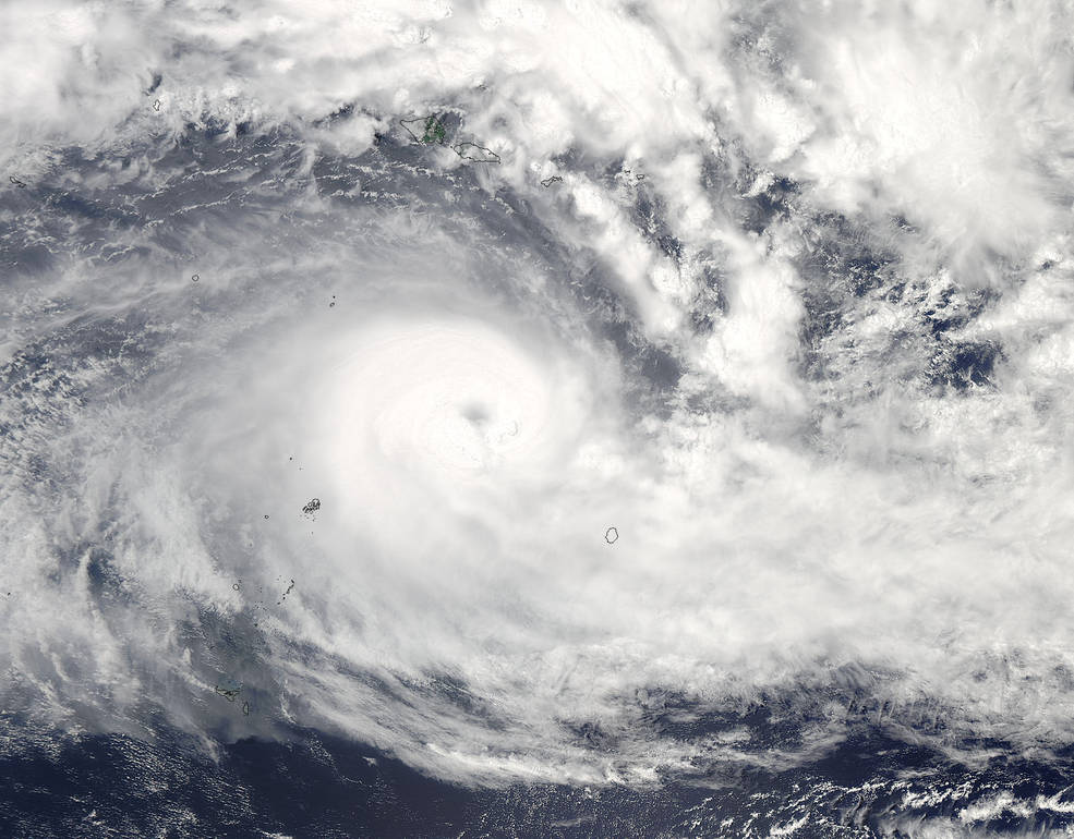
On February 17 at 01:00 UTC NASA's Aqua satellite captured this visible image of powerful Tropical Cyclone "Winston" in the South Pacific Ocean. Image credit: NASA Goddard MODIS Rapid Response/Jeff Schmaltz
The category 4 cyclone was packing maximum sustained winds of 166.7 km/h (103.6 mph) and gusts of 203.7 km/h (126.6 mph), which is equivalent to a category 2 hurricane on the Saffir-Simpson wind scale.
Winston is forecast to remain quasi-stationary over the next 24 hours, and then do a u-turn and start returning westward.
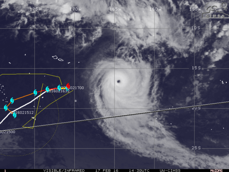
Tropical Cyclone "Winston" moving path, February 17, 2016, 14:30 UTC. Image credit: UW-CIMSS
A thin band of dry air, beginning to be entrained into the cyclone, was observed and is responsible for the lack of intensification over the last few hours. The same band will hamper the rate of future intensification, as well. Despite that, sea surface temperatures remain high, at about 30 °C (86 °F). Favorable upper-level conditions with low vertical wind shear, where the speeds are ranging between 18.5 and 27.8 km/h (11.5 and 17.3 mph), continue to persist, adding to the intensification.
Tropical Cyclone "Winston" will intensify to maximum sustained wind speeds of 212.9 km/h (132.3 mph) with gusts rising to 259.3 km/h (161.1 mph) over the next 48 hours. In the next three days, the cyclone will turn to the southeast again, as its wind speeds start to decrease slowly.
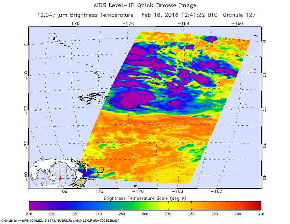
On February 16 the AIRS instrument aboard NASA's Aqua satellite saw cloud top temperatures in strong thunderstorms exceeding -53 °C (-63 °F) (purple) around the center of circulation. Image credit: NASA JPL, Ed Olsen
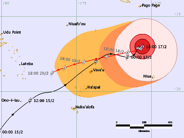
As Winston turns back on its journey, it will pass near the Vava'u group of islands. Tropical Cyclone Alert has been issued for Tonga Island on February 17 at 5:20 pm local time (04:20 UTC) by the Tonga Meteorological Service.
Damaging east to southeast gale force winds with average speed of 64.8 km/h (40.3 mph) and gusts up to 92.6 km/h (57.5 mph) are expected in the open waters of the east-northeast Vava'u, along with very rough to high seas and a heavy damaging east to southeast swell.
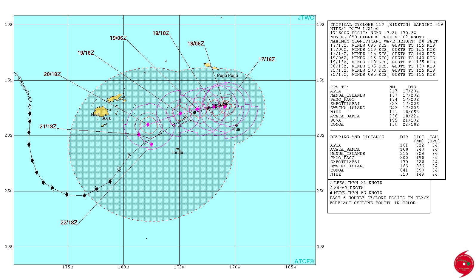
Tropical Cyclone "Winston" 6-day forecast track. Image credit: JTWC
East to southeast winds between 45 and 55 km/h (27.9 and 34.2 mph), rising to 65 km/h (40.4 mph), accompanied with possible scattered showers, are forecast for Tongatapu, 'Eua, Ha'apai, and Vava'u land areas. The coastal waters will experience east to the southeast winds in the same speed range, rough seas and a heavy damaging east to southeast swell.
Niuafo'ou and Niuatoputapu can expect west to southwest winds between 45 and 55 km/h (27.9 and 34.2 mph) with mostly cloudy skies and occasional showers while coastal waters have been forecast to experience rough seas and a heavy damaging south to southeast swell.
Tropical Cyclone "Winston" threat track map. Image credit: Fiji Meteorological Service/RSMC Nadi Tropical Cyclone Warning Center
Fiji Meteorological Service issued a Tropical Cyclone Warning for Niue Island. Damaging gale force winds may be experienced several hours before the center of the cyclone passes nearby. Average wind speeds are expected in the range of 65 km/h with gusts up to 90 km/h.
Periods of occasional heavy rainfall and squally thunderstorms are expected. Damaging heavy swells will likely cause flooding of low-lying coastal areas. High seas and damaging heavy swells are expected in the coastal waters, along with gale force winds up to 74 km/h (45.9 mph) and gusts of 101.9 km/h (63.3 mph).
Featured image: On February 17 at 01:00 UTC NASA's Aqua satellite captured this visible image of powerful Tropical Cyclone "Winston" in the South Pacific Ocean. Image credit: NASA Goddard MODIS Rapid Response/Jeff Schmaltz
Commenting rules and guidelines
We value the thoughts and opinions of our readers and welcome healthy discussions on our website. In order to maintain a respectful and positive community, we ask that all commenters follow these rules:
We reserve the right to remove any comments that violate these rules. By commenting on our website, you agree to abide by these guidelines. Thank you for helping to create a positive and welcoming environment for all.