Major winter storm underway from Central Rockies to High Plains, US
A major winter storm is well underway from the Central Rockies to the High Plains on Wednesday, March 23, 2016. Blizzard warnings are in effect from across northeastern Colorado to southeastern Wyoming, southwestern Nebraska, and northwestern Kansas. The storm is expected to intensify further as it moves towards the Great Lakes through Thursday, March 24.
At 15:00 UTC (09:00 MDT) today, a surface low pressure system with the central pressure of 990 hPa was located in southeastern Kansas, with a secondary center over northern Kansas. Cold air from Canada continues to spread southward while an upper-level trough from the Pacific interacts with the leading edge of the cold air mass over the Central Rockies. Doppler radars and surface observations at 14:00 UTC indicated light and moderate to locally heavy snow was rotating southward across the Central Rockies and the Central High Plains with the heaviest snow reported in the front range of Colorado.
According to Weather.com, up to 40.6 cm (16 inches) of snow was recorded in California as the system made its way across the West coast. Winter Storm Selene, as they named it, is dumping large amounts of snowfall at a very rapid rate.
In parts of Colorado, more than 50.8 cm (20 inches) of snow have already fallen, and more is on the way. Schools have been closed, and the heavy, wet snow is leading to widespread power outages. More than 90 000 people were without power. Some 700 flights into and out of Denver were canceled.
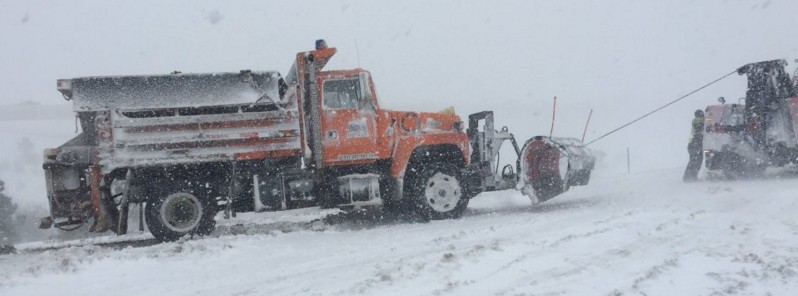
We beg you to stay off the roads. Emergency equip. is also stuck. Roads are beginning to close as well. pic.twitter.com/LwtRZagEjk
— CSP Castle Rock (@CSP_CastleRock) March 23, 2016
The storm forced a closure of Interstate 80 that spanned more than 480 km (300 miles) from Rock Springs to the Nebraska state line, according to the Associated Press. I-25 from Douglas to the Colorado state line was also closed Wednesday morning – a stretch of 225 km (140 miles).
Here's the latest look at how much #snow to expect from Winter Storm #Selene.https://t.co/OdlWlvAoZ0
— The Weather Channel (@weatherchannel) March 23, 2016
Forecast
The surface low pressure system will intensify as it moves east-northeastward towards the Great Lakes through Thursday, March 24, according to the NWS. Heavy snowfall combined with strong and gusty winds behind the intensifying low are expected to lead to blizzard conditions in the Central High Plains this afternoon into early evening before the storm center moves quickly across the Central Plains tonight. Meanwhile, snow is expected to spread eastward into the Upper Midwest and the Great Lakes tonight into Thursday morning with a band of freezing rain and sleet just to the south.
Snowfall totals of 10 to 20 (4 to 8 inches) with locally a foot can be expected from the Central Rockies east-northeastward across Nebraska into the Upper Midwest and the Central Great Lakes through Thursday into early Friday, March 25, NWS said.
According to AccuWeather's Senior Meteorologist Brett Anderson, although freezing rain is increasingly rare in the spring, it can occur under the right conditions. "The greatest risk for a significant period of freezing rain and sleet is from parts of central and northern Wisconsin and the upper part of the Lower Peninsula of Michigan to central Ontario and part of southern Quebec," Anderson said.
A fast, hard-hitting storm will spread snow from Colorado to Michigan: https://t.co/pVxSYjOMjH pic.twitter.com/XvCbxQpJfi
— AccuWeather.com (@breakingweather) March 23, 2016
"The snow and ice will graze northern parts of New York state, Vermont and New Hampshire, as well as northwestern Maine and northern New Brunswick. The greater Toronto, Ottawa and Montreal areas will receive a mixture of rain, ice and wet snow from the storm. The worst conditions in Toronto will be the Thursday morning commute when below-freezing temperatures will make untreated roads and sidewalks very slippery," Anderson said.
Featured image credit: CSP Castle Rock
Whatever happened to the saying that our children won’t know what snow is.From a climate doomsayer scientist.