Mount Karangetang erupts sending lava flows 2 km from crater, Indonesia
North Sulawesi's Mount Karangetang, Indonesia erupted around 09:00 UTC on April 27, 2016, and continued emitting ash on April 28.
Head of Sitaro Disaster Mitigation Agency (BPBD), Bob Chalton Wuaten, said the lava from the volcano started flowing at around 17:00 local time.
“It went toward the Kahetang River, around 2 km (1.2 miles) from the crater. The new dome on its peak collapsed during the eruption, causing the hot lava flow,” he said.
“There had been no volcanic activity in the last few days before it erupted on Wednesday afternoon,” said Abed Anthoni, a resident of Bebali subdistrict, East Siau district, for the Jakarta Post.
Anthoni added that East Siau residents did not consider yesterday’s eruption to be out of the ordinary, but remained alert in carrying out their daily activities.
Karangetang’s volcanic alert status remained at Level 2 (on a scale of 1-4), indicating the need for caution,
“We call on all residents in Boro, Tararone subdistrict, East Siau district, to stay alert because the potential for the volcano to spew pyroclastic clouds is still huge. The peak of Mt. Karangetang cannot be monitored visually because it is still shrouded with thick ash plumes,” said Wuaten.
Based on observations conducted at the Karangetang Volcano Observation Post in the village of Salili, PVMBG reported that between February 1 and March 13, 2016, the lava dome was incandescent at night. Variable amounts of white and blue emissions rose as high as 150 m (490 feet) above Main Crater.
Seismicity was dominated by shallow volcanic earthquakes; volcanic and multi-phase earthquakes declined though signals indicated that lava-dome growth continued. Thermal anomalies had not been detected in satellite images since March 8. The Alert Level was lowered to 2; visitors and residents were warned not to approach Karangetang within a 1.5-km (0.93 miles) radius.
Geological summary
Karangetang (Api Siau) volcano lies at the northern end of the island of Siau, north of Sulawesi. The stratovolcano contains five summit craters along a N-S line. It is one of Indonesia's most active volcanoes, with more than 40 eruptions recorded since 1675 and many additional small eruptions that were not documented in the historical record (Catalog of Active Volcanoes of the World: Neumann van Padang, 1951).
Twentieth-century eruptions have included frequent explosive activity sometimes accompanied by pyroclastic flows and lahars. Lava dome growth has occurred in the summit craters; the collapse of lava flow fronts has also produced pyroclastic flows. (GVP)
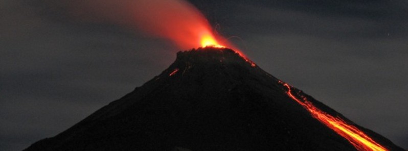
Featured image: A night time view of Mount Karangetang on August 28, 2007, shows incandescent ejecta from the summit crater and glowing rock avalanches down the flanks. Photo by Iyan Mulyana, 2007 (Centre of Volcanology & Geological Hazard Mitigation, Volcanological Survey of Indonesia).
Commenting rules and guidelines
We value the thoughts and opinions of our readers and welcome healthy discussions on our website. In order to maintain a respectful and positive community, we ask that all commenters follow these rules.