Intense rainstorm batters portions of South Australia, local flash floods reported
A spell of severe weather wrapped the south of Australia on May 9, 2016. Heavy rainfalls, accompanied by thunderstorms and strong winds, caused minor flash flooding and traffic disruptions across the affected areas. About 10 districts have been put on alert.
The weather conditions were brought on by a low pressure system which started moving from Adelaide toward the east, early on May 9 (local time). Large portions of Victoria, stretching from Port Campbell to Falls Creek, received abundant amounts of rain.
Almost 8 mm (0.3 inches) of precipitation fell in only 25 minutes in the Melbourne Central Business District while up to 15 mm (0.6 inches) was recorded by 5 pm (local time) across Melbourne. Heavy downpours were accompanied by a rapid temperature drop, from 22 to 17 °C (68 to 62.6 °F), and wind gusts up to 100 km/h (62.1 mph).
Melbourne has just been hit by a hectic & damaging weather front causing flash flooding & chaos on the #landscape pic.twitter.com/8tymgUwG8M
— richard morris (@morrisoutside) May 9, 2016
Flood warnings issued as Adelaide, other parts of South Australia, … https://t.co/AtoFzVhluW via @BreakingNews pic.twitter.com/MTPKDmgZrC
— Breaking411 News (@breaking411) May 9, 2016
The region of Adelaide suffered the strongest damage. A car was crushed, trees downed and thousands of residents have experienced power loss. The beaches across Adelaide have been battered by large waves, combined with a king tide. The Port River flooded and inundated numerous local houses and business. About 9 000 buildings suffered power loss.
Flooding was expected across the affected areas, and as many as 10 districts have been put on alert. Large tides have been forecast for the Outer Harbour, near Port Adelaide. Tasmania was also expecting a blow from the severe weather spell. Australian Bureau of Meteorology (BOM) warned the people the high seas, rising up to 3.6 m (11.8 feet), could inundate the local low-lying areas.
Adelaide cops a battering – trees down, power cut and the threat of major flooding. @EdwardGodfrey9 LIVE #9NewsAt6 pic.twitter.com/Imyt8MMlYR
— Nine News Adelaide (@9NewsAdel) May 9, 2016
More pics of flooding at Port Adelaide by Chris Messenger. pic.twitter.com/FzXkJli7QD
— 891Adelaide (@891adelaide) May 9, 2016
"We have a severe weather warning for most of the state. For alpine areas that warning is concentrated around severe winds with gusts up to 100 km/h (62.1 mph) and for the Melbourne area and southwest of the state the warning is more centered on heavy rainfall," said forecaster Alan Baillie.
Low lying Adelaide coastal residents on flood watch – we haven't even hit high tide yet! pic.twitter.com/vtc9FiKuk9
— Kate Freebairn (@katefreebairn) May 9, 2016
"We're expecting just generally astronomical high tides to be quite high at the moment. With the added heights that a bit of low pressure gives, we might just see some low-lying areas be inundated this afternoon with the high tide," said Rachel McInerney, BOM forecaster.
Severe weather will loosen its grip toward the afternoon of May 10. However, showers and winds up to 50 km/h (31 mph) are still expected in Adelaide in the morning hours.
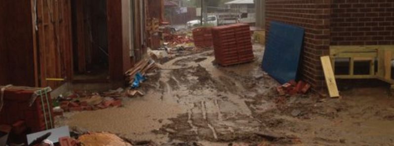
Featured image: Severe weather conditions in Melbourne, May 9, 2016. Image credit: Richard Morris via Twitter
Commenting rules and guidelines
We value the thoughts and opinions of our readers and welcome healthy discussions on our website. In order to maintain a respectful and positive community, we ask that all commenters follow these rules:
We reserve the right to remove any comments that violate these rules. By commenting on our website, you agree to abide by these guidelines. Thank you for helping to create a positive and welcoming environment for all.