The peak of northern hemisphere’s 2016 tropical cyclone season
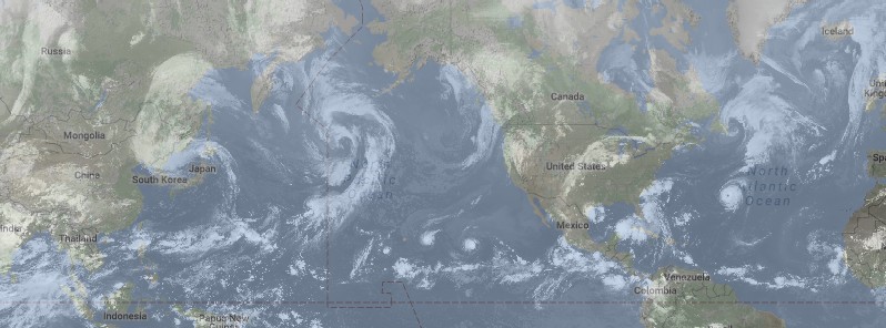
As of August 30, 2016, there are six active tropical cyclones across the Atlantic and Pacific ocean. In the Pacific, they are Hurricane "Madeline," Hurricane "Lester," and Tropical Storm "Lionrock." In the Atlantic, they are tropical depressions Nine and Eight, both expected to become tropical storms today, and Hurricane "Gaston," the strongest hurricane of the 2016 Atlantic season so far. Climatologically speaking, the northern hemisphere tropical cyclone season is most active through late August and the first half of September and this year is no exception.
While Hurricanes Madeline and Lester are expected to make a dangerously close pass near Hawaii over the next couple of days, Lionrock, some 6 300 km (3 900 miles) to the west, has already made landfall over the northern Honshu, Japan.
Tropical Depression Nine is expected to become a tropical storm today and make Florida landfall early Thursday local time, September 1. This system is currently dumping heavy rain on Cuba and will continue to do so as it heads toward Florida. Tropical Depression Eight is near the coast of North Carolina. Landfall is not expected as a turn toward the NNE is forecast over the next 24 hours.
Meanwhile, Hurricane "Gaston" is spinning far off the US coast and is now heading towards the Azores.

Video courtesy UK Met Office

Video courtesy Weather Nation. Imagery credit: ISS
Lionrock
Tropical Cyclone "Lionrock" was born on August 19, east of Japan together with two more tropical cyclones, one of which became deadly after it made a direct hit to Tokyo on August 22.
Lionrock made landfall near Ofunato in northern Japan on Tuesday afternoon local time, August 30. According to the Japan Meteorological Agency, it was the first typhoon to hit this area since 1951.
Lionrock produced widespread rainfall of 50 – 100 mm (2 – 4 inches) over the past several days. In Chichibu, it produced nearly 150 mm (6 inches) of rain in just 12 hours. Lionrock's impact resulted in numerous travel delays.
A large non-tropical system over the Sea of Japan in combination with Lionrock's remains is expected to produce rainfall totals over 150 mm (6 inches) across northeast China and Russia's Marine territory through Thursday, September 1.
Credit: UW-CIMSS
Madeline
Hurricanes "Madeline" and "Lester" are moving west, toward Hawaii, and are expected to pass dangerously close to the Big Island over the next couple of days. A direct impact, however, is not expected.
At of 15:00 UTC on August 30, Madeline was a major hurricane tracking westward toward the Hawaiian Islands. It was located about 1 025 km (635 miles) east of Honolulu and 715 km (445 miles) east of Hilo, Hawaii. Its maximum sustained winds were 195 km/h (120 mph), making Madeline a category 3 hurricane on the Saffir-Simpson Hurricane Wind Scale.
Madeline is moving west at 17 km/h (10 mph) with the estimated minimum central pressure of 958 hPa, according to NWS/CPHC. Some weakening is forecast through early Thursday local time, September 1.
A Tropical Storm Warning and a Hurricane Watch are now in effect for Hawaii County. Tropical Storm Watch is in effect for Maui County including the islands of Maui Molokai and Lanai.
On the current forecast track, the center of Madeline will pass dangerously close to the Big Island Wednesday and Wednesday night local time, August 31.
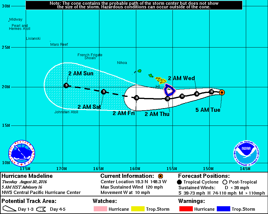
Hurricane "Madeline" forecast track by NWS/CPHC on August 30, 2016
Heavy rains associated with Madeline may reach Hawaii County on Wednesday, and may impact other Hawaiian Islands later Wednesday into Friday.
Madeline is expected to produce total rain accumulations of 127 to 254 mm (5 to 10 inches), with isolated maximum amounts near 381 mm (15 inches), across the Big Island, especially over windward portions.
This rainfall may lead to dangerous flash floods and mudslides. Madeline may produce up to 101.6 mm (4 inches) of rainfall across Maui County.
Lester
At 15:00 UTC on August 30, Lester was also a major hurricane heading towards Hawaii. Its center was located about 2 180 km (1 355 miles) east of Hilo, Hawaii.
Lester's maximum sustained winds are currently 195 km (120 mph), although this system is already weakening. The system is moving west at 22 km/h (14 mph) with the minimum estimated central pressure of 961 hPa.
There are currently no coastal watches or warnings in effect.
Gradual weakening is forecast during the next 48 hours.
Hurricane-force winds extend outward up to 55 km (35 miles) from the center and tropical-storm-force winds extend outward up to 150 km (90 miles).
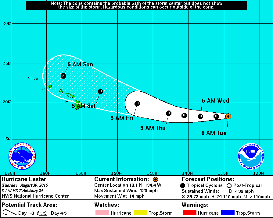
Hurricane "Lester" forecast track by NWS/CPHC on August 30, 2016
Tropical Depression Nine
At of 15:00 UTC on August 30, the center of Tropical Depression Nine was located about 495 km (310 miles) west of Havana, Cuba and 550 km (340 miles) west of Key West, Florida.
The depression is moving toward the west-northwest near 11 km/h (7 mph). A turn toward the northwest is expected later today, followed by a turn toward the north-northwest tonight. A turn toward the north-northeast is expected on Wednesday.
On the current forecast track, the center of the depression will continue to move slowly away from western Cuba, and move over the eastern Gulf of Mexico during the next 48 hours.
Maximum sustained winds are near 55 km/h (35 mph) with higher gusts. Some strengthening is forecast during the next 48 hours, and the depression is expected to become a tropical storm today.
The estimated minimum central pressure is 1 004 hPa.
The depression is expected to produce additional rain accumulations of 50.8 to 101.6 mm (2 to 4 inches) over western Cuba through Wednesday, with maximum storm total amounts up to 304.8 mm (12 inches). These rains could cause life-threatening flash floods and mud slides.
Storm total rainfall amounts of 127 to 254 mm (5 to 10 inches) are possible over much of the Florida peninsula through Friday morning local time, with isolated maximum amounts of 381 mm (15 inches) possible. This rainfall may cause flooding and flash flooding.
Given the current forecast, a tropical storm watch may be required for a portion of the Florida Gulf coast later today.
At the moment, there is no intensity guidance that makes this system a hurricane before Florida landfall on Thursday morning local time, September 1.
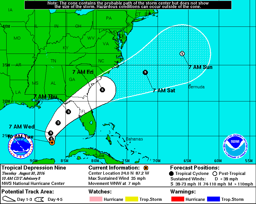
Tropical Depression Nine forecast track by NWS on August 30, 2016
Tropical Depression Eight
At 15:00 UTC today, the center of Tropical Depression Eight was located about 115 km (70 miles) south of Cape Hatteras, North Carolina, US.
The depression is moving toward the north-northwest near 7 km/h (5 mph). A turn toward the north is expected later today, and a turn toward the northeast is forecast on Wednesday.
On the current forecast track, the center of the depression will be near the Outer Banks of North Carolina this afternoon or this evening local time. Maximum sustained winds are near 55 km/h (35 mph) with higher gusts. Slow strengthening is forecast during the next 48 hours, and the depression could become a tropical storm later today.
The minimum central pressure from Air Force Reserve Hurricane Hunter aircraft data is 1 011 hPa.
A tropical storm warning is in effect for the coast of North Carolina from Cape Lookout to Oregon Inlet, and for Pamlico Sound.
The depression is expected to produce total rain accumulations of 25.4 to 76.2 mm (1 to 3 inches) with isolated maximum amounts of 127 mm (5 inches) over far eastern North Carolina, including the Outer Banks.
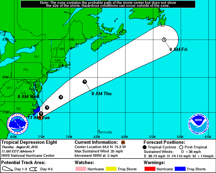
Tropical Depression Eight forecast track by NWS on August 30, 2016
Hurricane "Gaston"
Gaston formed near Africa's west coast on August 22 and briefly attained a category 1 hurricane status on August 25, before returning to tropical storm strength on the same day. It was heading NNW, towards the United States, as it re-strengthened and became a category 3 hurricane on August 28, the strongest of the 2016 Atlantic season so far. On August 29, it made a turn towards the NNE.
This cyclone is expected to retain its hurricane status for much of the work week, before having some impact as a tropical storm on Portugal’s Azores Islands by the weekend.
At 15:00 UTC on August 30, the eye of Hurricane "Gaston" was located about 2 430 km (1 510 miles) west of the Azores. Gaston is moving toward the east-northeast near 13 km/h (8 mph), and this general motion with an increase in forward speed is expected during the next couple of days.
Maximum sustained winds have increased to near 165 km/h (105 mph) with higher gusts. Little change in strength is forecast during the next 48 hours.
Hurricane-force winds extend outward up to 65 km (40 miles) from the center and tropical-storm-force winds extend outward up to 220 km (140 miles). The estimated minimum central pressure is 968 hPa.
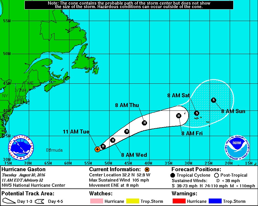
Hurricane "Gaston" forecast track by NWS on August 30, 2016
Featured image: IR image taken 14:00 UTC on August 30, 2016. Credit: UW-CIMSS
Commenting rules and guidelines
We value the thoughts and opinions of our readers and welcome healthy discussions on our website. In order to maintain a respectful and positive community, we ask that all commenters follow these rules:
We reserve the right to remove any comments that violate these rules. By commenting on our website, you agree to abide by these guidelines. Thank you for helping to create a positive and welcoming environment for all.