Hurricane “Lester” passing northeast of Hawaiian Islands

Hurricane "Lester" is passing northeast of Hawaiian Islands as a category 1 hurricane on the Saffir-Simpson Hurricane Wind Scale on September 3, 2016. Gradual weakening is forecast during the next 48 hours.
A Hurricane Watch is in effect for the Maui County including the islands of Maui, Molokai, Lanai and Kahoolawe, and Oahu. A Hurricane Watch means that hurricane conditions are possible within the watch area. Hurricane and tropical storm conditions are possible in the next 18 to 36 hours.
At 12:00 UTC on September 3, the center of Hurricane "Lester" was located about 275 km (170 miles) ENE of Hilo and 480 km (300 miles) E of Honolulu, Hawaii.
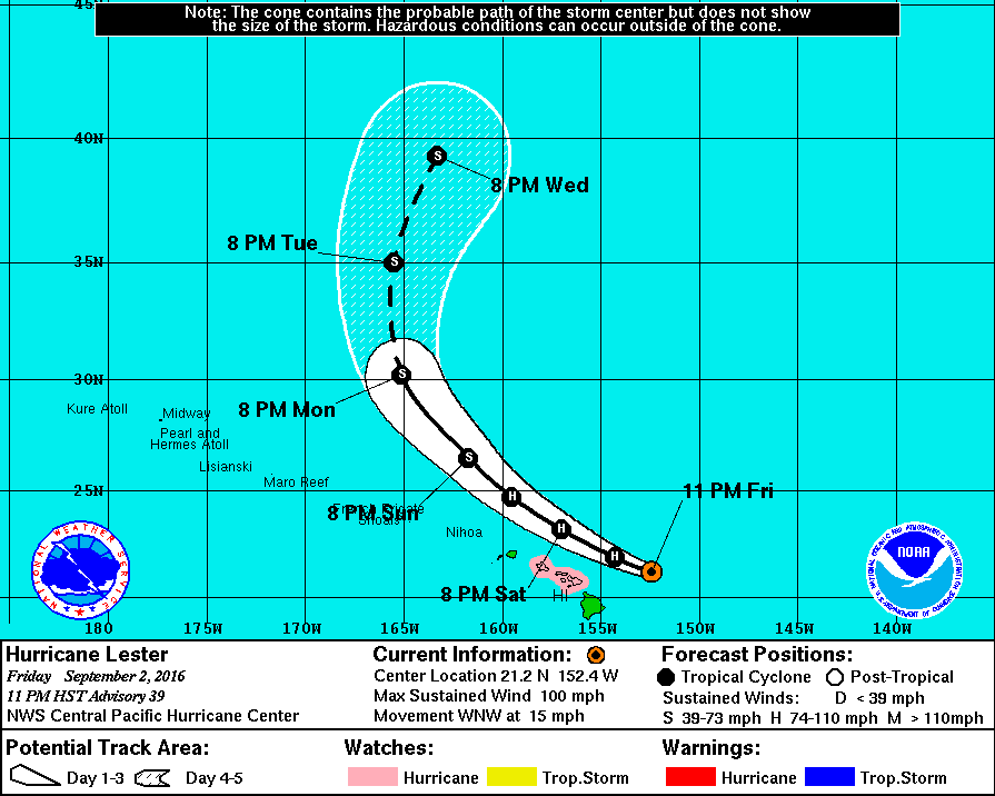
Hurricane "Lester" forecast track by NWS/CPHC on September 2, 2016
The system is moving toward the west-northwest near 24 km/h (15 mph) and this general motion is expected to continue through Saturday night with a gradual turn toward the northwest expected on Sunday, NWS/CPHC said.
Maximum sustained winds are currently near 155 km/h (100 mph) with higher gusts. Gradual weakening is forecast during the next 48 hours.
Hurricane-force winds extend outward up to 75 km (45 miles) from the center and tropical-storm-force winds extend outward up to 240 km (150 miles).
The estimated minimum central pressure is 982 hPa.
CPHC warned that hurricane conditions are possible over Maui County and Oahu late Saturday or Saturday night (local time), and tropical storm conditions are possible as early as Saturday afternoon.
Large swells generated by Lester will build across Hawaiian waters tonight and Saturday. Surf generated by these swells will peak during the weekend across the main Hawaiian islands, becoming very large and possibly damaging along exposed shorelines.
Heavy rains associated with Lester may impact Maui County and Oahu Saturday and Sunday.
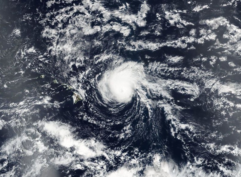
Hurricane "Lester" on September 2, 2016. Credit: NASA/NOAA/DoD Suomi NPP / VIIRS
On September 1, Tropical Storm "Madeline," once a major hurricane, passed south of the Big Island of Hawaii with maximum sustained winds near 100 km/h (65 mph). Madeline weakened to a tropical storm before UTC midnight of August 31.
At 12:45 UTC on September 2, when NASA's Aqua satellite passed over, Madeline was a tropical depression located about 644 km (400 miles) away from the Big Island.
An infrared image from Aqua's Moderate Resolution Imaging Spectroradiometer showed a small area of cloud tops in Tropical Depression "Madeline" were as cold as -56.6 °C (-70 °F). Cloud top temperatures that cold indicate storms are stretching high into the troposphere and have been shown to generate heavy rain.
CPHC forecasters said that satellite imagery like the infrared data from Aqua showed that convection (rising air that forms the thunderstorms that make up a tropical cyclone) and development of thunderstorms has increased near Madeline's low level circulation center, but vertical wind shear and dry mid-level air continues to hamper any attempt of re-organization.
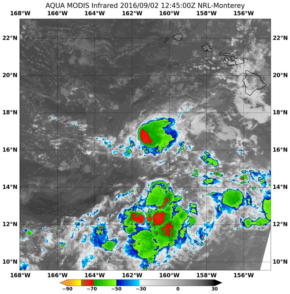
Image credit: NASA Aqua/MODIS
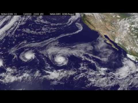
This animation of NOAA's GOES-West satellite imagery from August 30 to September 2 shows Tropical Storm "Madeline" move past Hawaii and weaken to a depression and Hurricane "Lester" approaching the Hawaiian Islands. Credits: NASA/NOAA GOES Project
Featured image: Hurricane "Lester" on September 2, 2016. Credit: NASA/NOAA/DoD Suomi NPP / VIIRS
Commenting rules and guidelines
We value the thoughts and opinions of our readers and welcome healthy discussions on our website. In order to maintain a respectful and positive community, we ask that all commenters follow these rules:
We reserve the right to remove any comments that violate these rules. By commenting on our website, you agree to abide by these guidelines. Thank you for helping to create a positive and welcoming environment for all.