Alert status of Mayon volcano raised, ‘big’ eruption possible, Philippines
On Thursday, September 8, 2016, the Philippine Institute of Volcanology and Seismology (PHIVOLCS) has raised the alert status of Mayon volcano from Alert Level 0 to Alert Level 1. This means that the volcano is in an abnormal condition and has entered a period of unrest. Mayon is an active stratovolcano in the province of Albay in Bicol Region, on the island of Luzon in the Philippines.
Although no crater glow has been observed, PHIVOLCS warns a phreatic explosion that could lead to a big explosive eruption can happen anytime. The abnormal activity is similar to what happened to the Mayon eruption of 1984 [VEI 3], Eduardo Laguerta, PHIVOLCS resident volcanologist in Bicol said.
No casualties were recorded from the 1984 eruption after more than 73 000 people were evacuated from the danger zones as recommended by PHIVOLCS. But in 1993, pyroclastic flows killed 75 people, mainly farmers.
"The massive drying up of wells across Albay, specifically in the municipalities surrounding the volcano, may be attributed to the magma movement activity beneath the restive volcano," Laguerta said and added that while magma build-up did not progress past the belly of the volcano during its explosion in 2014, a "magmatic eruption" may happen this time around.
"Today the possibility continues for magmatic eruption and we cannot discount the possibility of big explosion. Phreatic explosions usually occur before the big explosion," he said.
There are 18 000 people living along the slopes of the volcano, said Cedric Daep, Albay Public Safety and Emergency Management Office chief.
PHIVOLCS said they have recently observed an increase in the monitored parameters of Mayon Volcano, as follows:
- Gas emission: Sulfur Dioxide emission or SO2 flux from Mayon crater based on campaign and continuous gas measurements has consistently increased beyond the baseline level of 500 tons/day, exceeding 1 000 tons/day in some days, since July 2016. SO2 flux tends to increase through time as magma degasses with increasing rates as it moves up from great depths beneath the volcano.
- Ground deformation: Continuous GPS and tilt measurements show a continuous inflationary trend since July 2016. Results of Precise leveling and electronic distance surveys on the last week of August 2016 indicate inflation of the edifice, possibly due to magma movement at depth.
- Volcanic earthquake activity: A total of 146 earthquakes were recorded by Mayon Volcano Observatory seismic network from August 3 to August 6, which were located on the southeast side 10 km (6.2 miles) away from the volcano. This earthquake swarm likely emanated from rock-fracturing processes that may or may not be associated with magmatic activity. However, seismicity has remained below baseline in the weeks succeeding the swarm.
- Other observations: Four of the 14 monitored water wells located on the southeastern side of Mayon are experiencing a decrease in water discharge while one well has dried-up. Steaming activity from the crater has ranged from weak to moderate. No crater glow has been observed so far.
The public is reminded to avoid entry into the 6-km (3.7 miles) Permanent Danger Zone or PDZ due to perennial hazards of rockfalls, avalanches, ash puffs and sudden steam-driven or phreatic eruption at the summit area which may occur without warning, PHIVOLCS said.
Furthermore, people living in valleys and active river channels are cautioned to remain vigilant against sediment-laden streamflows and lahars in the event of prolonged and heavy rainfall brought about by the advent of the rainy season.
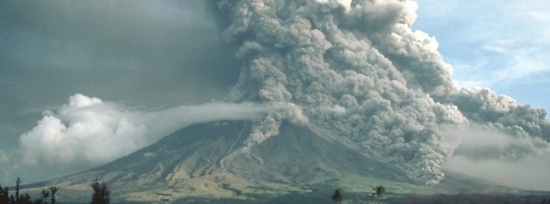
Pyroclastic flows at Mayon Volcano, Philippines, 1984. Pyroclastic flows descend the south-eastern flank of Mayon Volcano, Philippines. Maximum height of the eruption column was 15 km (49 200 feet) above sea level, and volcanic ash fell within about 50 km (31 miles) toward the west. There were no casualties from the 1984 eruption because more than 73 000 people evacuated the danger zones as recommended by scientists of the Philippine Institute of Volcanology and Seismology. Credit: USGS / C.G. Newhall
Geological summary
Beautifully symmetrical Mayon volcano, which rises to 2462 m above the Albay Gulf, is the Philippines' most active volcano. The structurally simple volcano has steep upper slopes averaging 35-40 degrees that are capped by a small summit crater. Historical eruptions at this basaltic-andesitic volcano date back to 1616 and range from strombolian to basaltic plinian, with cyclical activity beginning with basaltic eruptions, followed by longer term andesitic lava flows.
Eruptions occur predominately from the central conduit and have also produced lava flows that travel far down the flanks. Pyroclastic flows and mudflows have commonly swept down many of the approximately 40 ravines that radiate from the summit and have often devastated populated lowland areas.
Mayon's most violent eruption, in 1814, killed more than 1200 people and devastated several towns. (GVP)
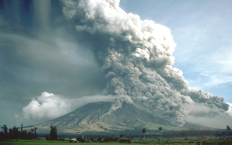
Featured image: Mayon eruption on September 23, 1984. Credit: USGS
Commenting rules and guidelines
We value the thoughts and opinions of our readers and welcome healthy discussions on our website. In order to maintain a respectful and positive community, we ask that all commenters follow these rules:
We reserve the right to remove any comments that violate these rules. By commenting on our website, you agree to abide by these guidelines. Thank you for helping to create a positive and welcoming environment for all.