Meranti is becoming a violent typhoon as it tracks toward Taiwan

Meranti became a typhoon on September 11, 2016, and underwent a rapid intensification phase over the next 24 hours. This monster storm is still intensifying and is expected to move through the Strait of Luzon on September 13, bringing heavy rain to Northern Luzon, Philippines. It will then pass with its center just south or over the southern tip of Taiwan after 00:00 UTC on September 14 on its way toward southeastern China landfall around 00:00 UTC on September 15.
As of 06:00 UTC on September 12, the center of Very Strong Typhoon "Meranti" was located about 993 km (617 miles) NE of Manila, Philippines and 1 120 km (696 miles) SE of Taipei City, Taiwan. Its maximum wind speed near the center was 185 km/h (115 mph) with wind gusts to 260 km/h (161 mph), according to the JMA.
Meranti is tracking WNW at 22.2 km/h (13.8 mph) with the minimum central pressure of 920 hPa.
JMA expects Meranti to become a Violent typhoon by 18:00 UTC today, with maximum wind speed near the center of 194 km/h (121 mph) and gusts to 278 km/h (172 mph). Its minimum estimated central pressure at the time is expected to be at 915 hPa. Meranti should be moving to the west at 28 km/h (17 mph).
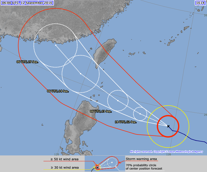
Typhoon "Meranti" forecast track by JMA at 06:00 UTC on September 12, 2016
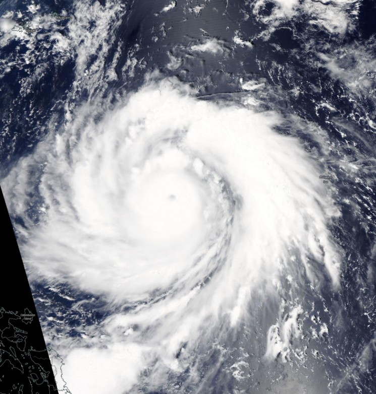
Typhoon "Meranti" on September 12, 2016. Credit: NASA Terra/MODIS
According to the JTWC's forecast track for Typhoon "Meranti" issued 00:00 UTC on September 12, the typhoon should impact the southern tip of Taiwan after 00:00 UTC on September 14 with maximum sustained winds of 231 km/h (143 mph) and gusts to 278 km/h (172 mph).
As per JTWC, Meranti should peak by 12:00 UTC on September 13 with maximum sustained winds of 250 km/h (155 mph) and gusts to 305 km/h (190 mph). This would place Meranti on the edge of Category 4 and 5 hurricane equivalent – a super typhoon. The system will then weaken as it approaches Taiwan and tracks just south of its mountainous terrain.
Category 4 and 5 hurricanes pose a threat for catastrophic damage to the impact area. Well-built framed homes can sustain severe damage with loss of most of the roof structure and/or some exterior walls. Most trees would be snapped or uprooted and power poles downed. Fallen trees and power poles would isolate residential areas, with power outages lasting weeks to possibly months. Most of the impacted area will be uninhabitable for weeks or months.
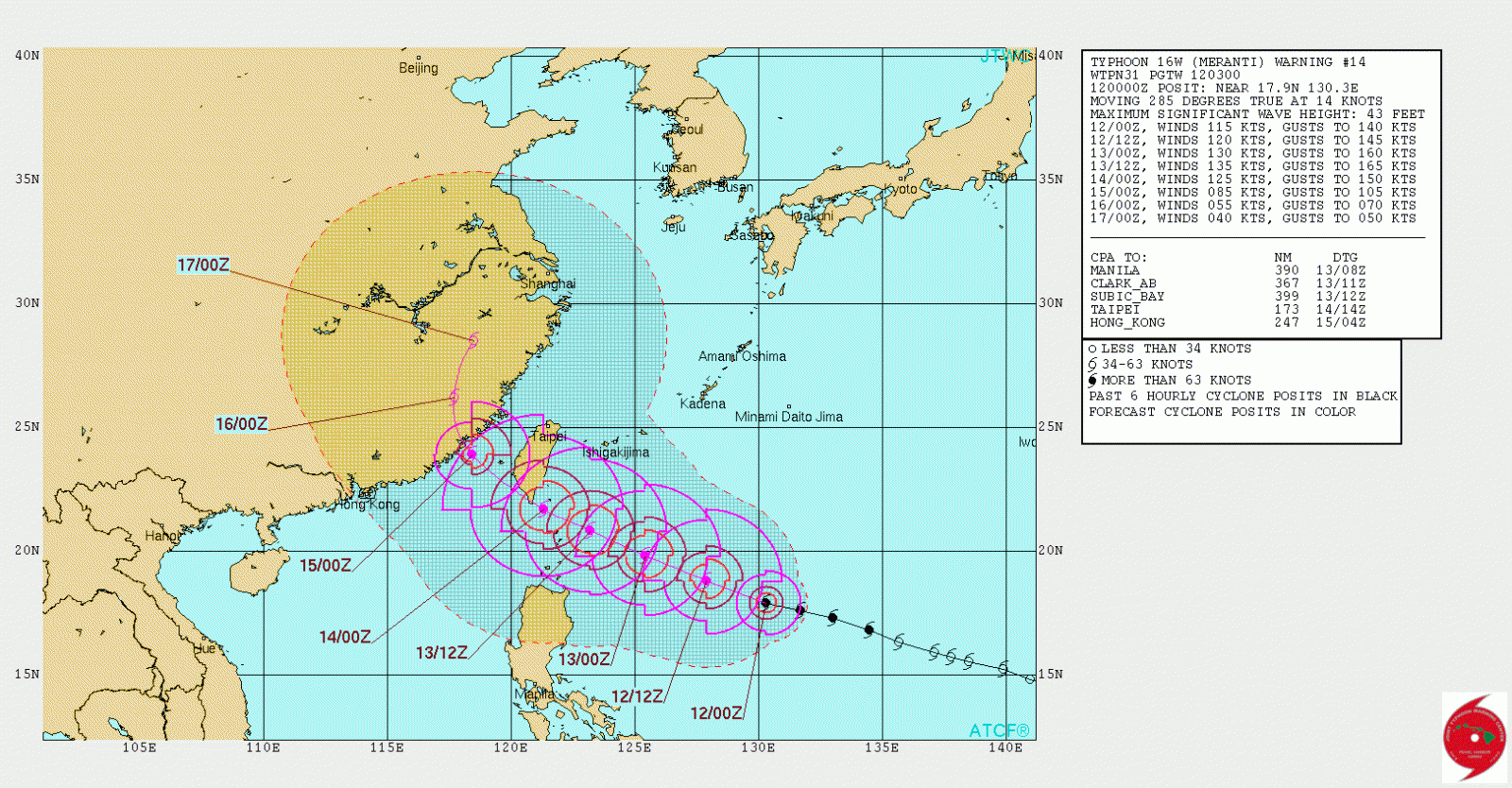
Typhoon "Meranti" forecast track by JTWC at 00:00 UTC on September 12, 2016
In their Prognostic Reasoning published 03:00 UTC today, JTWC said that a rapidly-consolidating low-level circulation center with spiral bands are wrapping into a 5-nm (9.3 km / 5.8 miles) pinhole eye. "Therefore, there is excellent confidence in the current position and recent track motion."
Upper-level analysis and animated water vapor imagery show a favorable environment with low vertical wind shear and near-radial outflow. Additionally, warm sea surface temperatures and high ocean heat content values support the current rapid intensification trend.
Over the next 72 hours, JTWC said, Meranti will track generally west-northwestward under the steering influence of the deep-layered subtropical ridge. However, after the next 48 hours, the model trackers diverge with significant uncertainty in the exact track near Taiwan.
After 72 hours, the dynamic model guidance diverges with two distinct clusters. The first cluster of models (UKMET, ECMWF, GFDN, and NAVGEM) have remained quite erratic and have now shifted from a re-curve track back to a more westward track into southeast China.
Analysis of available model fields indicates that these models are driving the system into the major trough rather than tracking it poleward toward the weakness in the subtropical ridge as the second cluster depicts.
"This scenario is currently assessed as unlikely / erroneous, therefore, the JTWC forecast favors the re-curve scenario as depicted by the second cluster of models (GFS, GFS ENSEMBLE, HWRF, JGSM ENSEMBLE, and COAMPS-TC). Meranti is forecast to make landfall along the southeastern coast of Taiwan near TAU 48 and will weaken significantly. The system will weaken further as it tracks over eastern China. Due to the large model spread beyond 48 hours, there is low confidence in the JTWC track forecast."
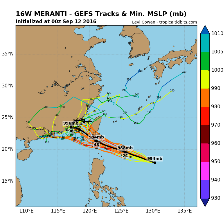
Image credit: TropicalTidbits.com

Video courtesy Robert Speta / WestPacWx – September 12, 2016
Featured image: Typhoon "Meranti" at 08:30 UTC on September 12, 2016. Credit: UW-CIMSS
Commenting rules and guidelines
We value the thoughts and opinions of our readers and welcome healthy discussions on our website. In order to maintain a respectful and positive community, we ask that all commenters follow these rules:
We reserve the right to remove any comments that violate these rules. By commenting on our website, you agree to abide by these guidelines. Thank you for helping to create a positive and welcoming environment for all.