Tropical Storm Mawar (Ambo) intensified as it continues to move northwestward across parts of Philippines
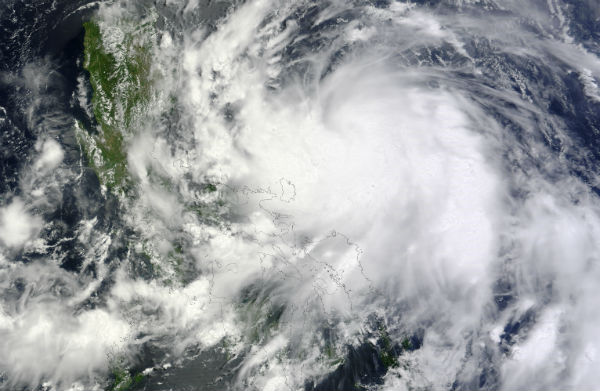
Tropical Depression Mawar (also known as Ambo or 04W) formed over the western Pacific Ocean on May 31, 2012, and strengthened to a tropical storm the following day. On June 1, 2012, the U.S. Navy’s Joint Typhoon Warning Center (JTWC) reported that Mawar was located approximately 215 nautical miles (400 km or 250 miles) east-northeast of Manila, Philippines. The storm had maximum sustained winds of just 35 knots (65 km/h or 40 mph), but over the next 48 hours, Mawar’s wind speeds were forecast to increase to 80 knots (150 km/h or 93 mph) with gusts up to 100 knots (185 km/h or 115 mph).


According to latest warning report issued by PAGASA at 4:00 a.m. today, Tropical Storm“AMBO” was estimated based on satellite, radar and surface data at 220 km (137 miles) east of Casiguran, Aurora (16.1°N, 124.6°E) with maximum sustained winds of 75 km/h (46 mph) near the center and gusts of up to 90 km/h (56 mph). It is forecast to move north-northwest at 13 km/h (8 mph).
Estimated rainfall amount is from 15 – 25 mm per hour (heavy) within the 500 km diameter of the Tropical Storm. TS “Ambo” is expected to enhance the Southwest Monsoon that will bring rains over Central and Southern Luzon and Visayas. Residents living in low lying and mountainous areas under signal # 1 are alerted against possible flashfloods and landslides.


Satellite Animations
- Storm-Centered Infrared (MTSAT2; NOAA/SSD)
- Storm-Centered Infrared (Aviation Color Enhancement) (MTSAT2; NOAA/SSD)
- Storm-Centered Water Vapor (MTSAT2; NOAA/SSD)
- Storm-Centered Visible (MTSAT2; NOAA/SSD)
- Storm-Centered Visible (Colorized) (MTSAT2; NOAA/SSD)
- West Pacific/South China Sea Infrared (MTSAT2; NOAA)
- West Pacific/South China Sea Enhanced Infrared (MTSAT2; NOAA)
- West Pacific/South China Sea Water Vapor (MTSAT2; NOAA)
Natural power is incredible.