Two extremely dangerous earthquakes M6.4 and M6.3 struck northwestern Iran
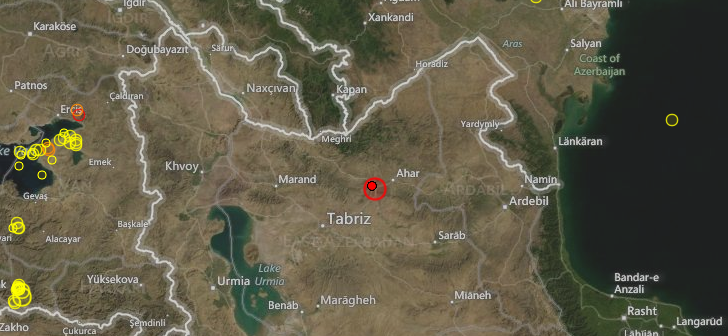
Northwestern Iran was struck by two strong and very shallow earthquakes on August 11, 20102 within only 15 minutes. USGS recorded earthquake with magnitude 6.4 at 12:23 UTC and second with magnitude 6.3 at 12:34 UTC. Recorded depth of both earthquakes was about 9.9 km (6.2 miles). Both earthquakes struck approximately the same area 20 km (12 miles) WSW of Ahar, Iran at 38.322°N, 46.888°E.
City of Tabriz is only 60km (37 miles) from epicenter area with population of 1.4 million people.
EMSC recorded magnitude 6.2 and 6.1 at depth of 10 km.
According to USGS there were 6 recorded aftershocks with magnitude greater than 4; and 15 aftershocks with magnitude above 3.5 according to EMSC by 18:37 UTC.
| 5.0 | 2012/08/11 15:43:19 | 38.275 | 46.617 | 10.0 | NORTHWESTERN IRAN |
| 4.7 | 2012/08/11 15:21:15 | 38.315 | 46.793 | 10.0 | NORTHWESTERN IRAN |
| 4.5 | 2012/08/11 14:25:15 | 38.039 | 46.644 | 10.0 | NORTHWESTERN IRAN |
| 4.8 | 2012/08/11 13:14:07 | 38.359 | 46.725 | 10.0 | NORTHWESTERN IRAN |
| 4.4 | 2012/08/11 13:05:55 | 38.606 | 46.986 | 10.0 | NORTHWESTERN IRAN |
| 4.8 | 2012/08/11 12:49:18 | 38.209 | 46.756 | 10.0 | NORTHWESTERN IRAN |
| 6.3 | 2012/08/11 12:34:35 | 38.324 | 46.759 | 9.8 | NORTHWESTERN IRAN |
| 6.4 | 2012/08/11 12:23:18 | 38.322 | 46.888 | 9.9 | NORTHWESTERN IRAN |
By 20:00 UTC state run agencies reported that 180 people were killed and 1300 were injured. 6 villages have been almost completely destroyed. 60 villages have sustained 50%-80% damages by earlier reports. The earthquake has cut off the gas supply to 70 villages in the Ahar area.
Labor news agency ILNA reports that Rescue services admitted tonight that 10 to 20 villages in the epicenter area have not been reached yet. The power is down in the earthquake stricken area and as many roads are blocked Search and Rescue work will be very difficult.
Iranian officials have announced that the figures from the death and wounded will increase due to the critical condition of the wounded.
According to the report of Presidential Office website, the Iran cabinet members expressed their deep sorrow over the earthquake incident which has caused so many people to die, and expressed sympathy with victims’ families. The government called on all natural disaster headquarters and responsible bodies to mobilize all their possibilities and releif equipment and provide quake-stricken areas with all kinds of necessary assistance. (ER)
| Magnitude | 6.4 |
|---|---|
| Date-Time |
|
| Location | 38.322°N, 46.888°E |
| Depth | 9.9 km (6.2 miles) |
| Region | NORTHWESTERN IRAN |
| Distances | 20 km (12 miles) WSW of Ahar, Iran 60 km (37 miles) ENE of Tabriz, Iran 95 km (59 miles) E of Marand, Iran 100 km (62 miles) SSE of Kapan, Armenia |
| Location Uncertainty | horizontal +/- 13.6 km (8.5 miles); depth +/- 3.8 km (2.4 miles) |
| Parameters | NST=448, Nph=452, Dmin=275 km, Rmss=1.21 sec, Gp= 36°, M-type=(unknown type), Version=C |
| Source |
|
| Event ID | usb000bupa |
| Magnitude | 6.3 |
|---|---|
| Date-Time |
|
| Location | 38.324°N, 46.759°E |
| Depth | 9.8 km (6.1 miles) |
| Region | NORTHWESTERN IRAN |
| Distances | 32 km (19 miles) WSW of Ahar, Iran 48 km (29 miles) ENE of Tabriz, Iran 86 km (53 miles) E of Marand, Iran 96 km (59 miles) NNW of Hashtrud, Iran |
| Location Uncertainty | horizontal +/- 14 km (8.7 miles); depth +/- 4 km (2.5 miles) |
| Parameters | NST=509, Nph=509, Dmin=267.2 km, Rmss=1.01 sec, Gp= 22°, M-type=regional moment magnitude (Mw), Version=9 |
| Source |
|
| Event ID | usb000buph |

Shake map

Pager map


Selected Cities Exposed from GeoNames Database of Cities with 1,000 or more residents.
| MMI | City | Population |
|---|---|---|
| VII | Ahar | 94k |
| V | Tabriz | 1,425k |
| V | Mincivan | 6k |
| V | Meghri | 5k |
| V | Icari | 7k |
| V | Hashtrud | 17k |
| V | Kapan | 33k |
| V | Ardabil | 411k |
| IV | Agcabadi | 35k |
| IV | Yeghegnadzor | 0 |
| IV | Kalbacar | 0 |
Historic seismicity since 1900

Historic seismicity since Jan 2012

Iran – major faultlines

Sources: USGS, EMSC, Earthquake-report
More information is coming in. This page will be updated accordingly.
[…] Yesterday – Two extremely dangerous earthquakes M6.4 and M6.3 struck northwestern Iran […]
[…] Continue Reading… […]
[…] relacionados: Dos terremotos dejan 180 muertos y 1.300 heridos en Irán Two extremely dangerous earthquakes M6.4 and M6.3 struck northwestern Iran Zionist Cabal Attacks Iran with HAARP Share this:TwitterFacebookMe gusta:Me gustaBe the first to […]
[…] Dos terremotos dejan 180 muertos y 1.300 heridos en Irán Two extremely dangerous earthquakes M6.4 a… Share this:TwitterFacebookMe gusta:Me gustaBe the first to like this. […]
I have been waiting for that for a while now. The HAARP Facilities must have stored up enough Energy in the upper Ionosphere, so it just took a while,but it looks like it is working and they finally achieved directional Control.
Look out for many more to come,however they will not create a Tsunami as in Japan.
So it will take much more intensity to produce the intended effects.