Climate impact risks map for European cities
The European Environment Agency (EEA) has published a series of detailed interactive maps of more than 500 cities across Europe, unveiling risks of adaptation to climate changes for six decades from now on the basis of likely global warming trends.
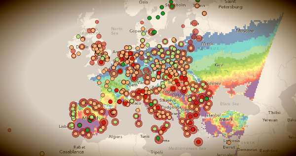
The recently published EEA report ‘Urban adaptation to climate change in Europe‘ provides an overview of frequency and intensity of river floods and extreme temperature events in many parts of Europe. The interactive maps allow users to explore data from more than 500 cities in Europe and get a quick impression of some of the adaptation challenges in Europe’s cities.

Southern Spain, parts of southern France, Italy, Greece, Serbia and western Turkey are most exposed. These regions are likely to notch up more than 50 days in the year when day temperatures will be greater than 35 degrees Celsius (95 degrees Fahrenheit) and nighttime temperatures will not dip below 20 C (68 F). The northern rim of continental Europe, the British Isles, Scandinavia and the southern Baltic will have the least heatwave risk, according to the model, which looks at 2071-2100.
Maps dataset includes: Heat wave risk of European cities, Coastal flooding risk in European cities due to sea level rise and storm surges and more.
Maps included in the report are available on the interactive Eye on Earth information service.
European Climate Adaptation Platform CLIMATE-ADAPT
Broken links are relinked to better understand our future and I further believe as more truth is revealed about our catastrophic past that we are truly amongst enlightened humans to illustrate our astonishing demise.
Watch the video and read about Henrik Svensmark regarding his work with CERN, The SKY/CLOUD Experiments or Galactic Cosmic Rays vs Cloud Cover – Galactic Cosmic Rays vs Global Temperature and connect the dots of clarity.
Listen to his inflections and sincerity regarding the subject matter supported by research @ the 9:40 mark of the video. I would like to know what book he is using to support his statements featured in the background as he cogently lays down the frame work for his research.
http://www.youtube.com/watch?v=YIumyR_uuCg&feature=player_embedded#!
Henrik Svensmark of CERN and his research regarding Cosmic Rays vs Cloud Cover & Global Temperatures.
https://en.wikipedia.org/wiki/Svensmark
This is a great map and great idea so people can adjust their plans. Is there a map like this for the states? Thank You