Super Typhoon Haiyan rages toward central Philippines as the strongest storm of the year
Strengthening Super Typhoon Haiyan (Yolanda) is posing a serious threat to the Philippines. Right now Haiyan is equal to an extremely powerful Category 5 hurricane in the Atlantic, spinning with powerful 333 km/h (207 mph) winds. Haiyan is now the strongest tropical system in the world for the 2013 season as estimated by wind speed and central pressure. It is expected to make landfall in the Philippines as equivalent of Category 4 or even Category 5 hurricane late on November 8, 2013.
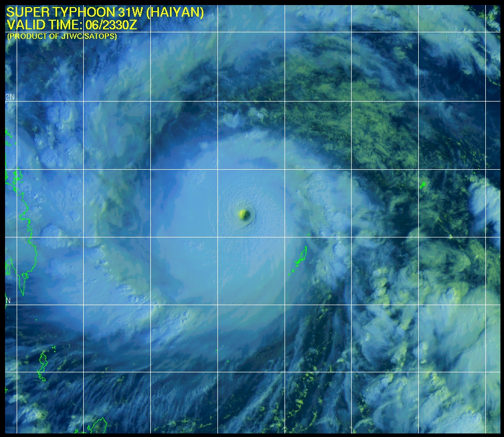
Multispectral satellite imagery – 23:30 UTC on November 6, 2013 (Credit: JTWC/SATOPS)
According to latest report by Joint Typhoon Warning Center (JTWC), the center of Super Typhoon Haiyan was located approximately 123 nm northwest of Koror, Palau. The system is moving west-northwestward at 16 knots (30 km/h, 18 mph). Maximum significant wave height is 14, 5 meters (46 feet).
Maximum sustained winds are 150 knots (277 km/h, 172 mph) with gusts up to 180 knots (333 km/h, 207 mph). Sea surface temperatures along the track remain very favorable providing ample surface heating, supporting the super typhoon intensity over the past few hours.
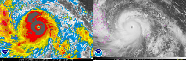
MTSAT satellite imagery – 04:57 UTC on November 7, 2013 (Credit: NOAA/MTSAT)
Torrential rain and damaging winds will accompany Haiyan through the central Philippines, triggering life-threatening flash floods, as well as severe and inundating storm surge, especially along the eastern coast of southern Luzon and Samar islands.
Rain totals along the path of Haiyan could top 200 mm (8 inches). Mudslides are a serious concern in the higher terrain, where localized totals of 250 to 300 mm (10 to 12 inches) of rain could be expected.
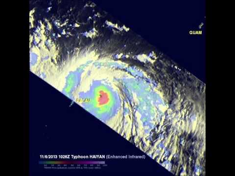
Data from TRMM's TMI and PR instruments on November 6, 2013 at 1026 UTC revealed that rain was falling at a rate of over 100mm/~3.9 inches per hour (purple)around Haiyan's eye. (Credit: NASA/SSAI Hal Pierce)

ST Haiyan forecast track (Credit: JTWC)
The expected track of Haiyan will take it directly over the areas hardest hit by a powerful 7.1 magnitude earthquake that devastated area in the middle of October. The U.S. National Hurricane Center website indicates that a Category 5 hurricane/typhoon would cause catastrophic damage: A high percentage of framed homes will be destroyed, with total roof failure and wall collapse. Fallen trees and power poles will isolate residential areas. Power outages will last for weeks to possibly months. Most of the area will be uninhabitable for weeks or months.
Thousands of people are being evacuated.
According to PAGASA, after hitting Guiuan, the system is expected to traverse the provinces of Leyte, Biliran, Northern tip of Cebu, Iloilo, Capiz, Aklan, Romblon, Semirara Island, Southern part of Mindoro then Busuanga and will exit the Philippine landmass (Saturday Morning) towards the West Philippine Sea.

Super Typhoon Haiyan forecat track (Credit: PAGASA)
Haiyan will remain a dangerous cyclone as it emerges into the South China Sea and continues to move to the west-northwest toward Vietnam by late November 10, 2013. Flooding and mudslides are going to be the most serious threats for affected areas.
.jpg)
Satellite Animations
- Storm-Centered Infrared (MTSAT; NOAA/SSD)
- Storm-Centered Infrared (Aviation Color Enhancement) (MTSAT; NOAA/SSD)
- Storm-Centered Water Vapor (MTSAT; NOAA/SSD)
- Storm-Centered Visible (MTSAT; NOAA/SSD)
- Storm-Centered Visible (Colorized) (MTSAT; NOAA/SSD)
- Tropical West Pacific Infrared (MTSAT2; NOAA)
- Tropical West Pacific Enhanced Infrared (MTSAT2; NOAA)
- Tropical West Pacific Water Vapor (MTSAT2; NOAA)
- Tropical West Pacific Visible (MTSAT2; NOAA)
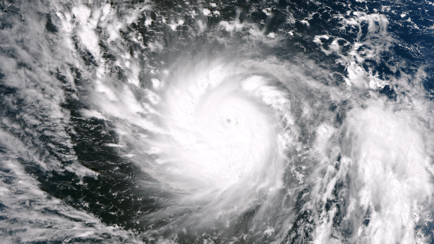
Featured image: Suomi NPP/VIIRS satellite image of Super Typhoon Haiyan at 02:25 UTC on November 6, 2013 (Credit: NASA/SUOMI NPP)
Commenting rules and guidelines
We value the thoughts and opinions of our readers and welcome healthy discussions on our website. In order to maintain a respectful and positive community, we ask that all commenters follow these rules.