Unusual Tropical Cyclone “Nilofar” developed in Arabian Sea
feat.jpg)
Low pressure area (Invest 90A) over the Arabian Sea has become better organized and developed into Tropical Cyclone "Nilofar". The system has the potential to strengthen to the equivalent of a Category 1 hurricane before its Arabian Peninsula landfall.
(1).jpg)
METEOSAT-7 Infrared satellite image taken at 18:00 UTC on October 25, 2014. (Credit: NOAA/UW-CIMSS)
Nilofar is expected to slam onshore, threatening eastern Yemen or Oman with damaging winds, flooding rain and dangerously rough seas. The system could cross back over the Arabian Sea and bring potentially heavy rainfall to parts of Pakistan and northwestern India, as a significant cyclone capable of producing damaging winds, flooding and mudslides.

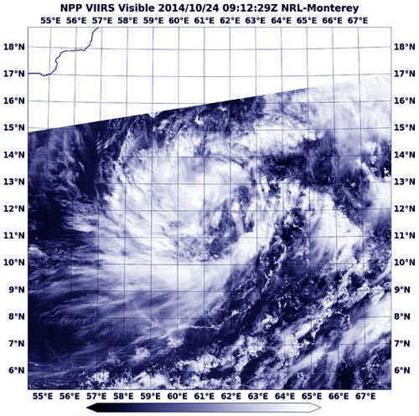
The VIIRS instrument aboard NOAA-NASA's Suomi NPP satellite captured this visible image of System 90A on October 24, 2014. (NOAA/NRL Monterrey)
According to latest public advisory issued by Joint Typhoon Warning Center (JTWC) at 21:00 UTC on October 25, 2014, Tropical Cyclone Nilofar (TC 04A) was located approximately 469 nautical miles (868 km/539 miles) south-southeast of Masirah Island, and has tracked northeastward at speed of 11 km/h (7 mph). A recent ship observation southeast of the system indicated southerly maximum sustainable winds at 60 km/h (37 mph), gusting up to 83 km/h (51.5 mph).
Nilofar is forecast to turn northwestward towards Oman coast and re-curve northeastward after as a midlatitude shortwave trough deepens over the northern Arabian Sea. Nilofar is expected to slowly consolidate through the next 24 hours but should intensify at a faster rate until reaching the peak intensity of 130 km/h (80 mph), gusting up to 160 km/h (100 mph) around late October 28, 2014. Thereafter, Nilofar will weaken due to increasing vertical wind shear, land interaction and dry air intrusion.
.png)
TC Nilofar forecast track (Credit: JTWC)
Tropical cyclones are unusual in this region of the world, however, they are not rare. One or two tropical cyclones form every year in Arabian Sea.
Cyclone "Gonu" hit Oman and southern Iran in June 2007 as the most intense Arabian Sea storm on record, with maximum sustained winds of 240 km/h (150 mph). Gonu claimed more than 100 lives. Category 4 Cyclone "Phet" made landfall on the eastern tip of Oman, east of the capital city of Muscat in June 2010 as Category 1 cyclone. Cyclone ARB 01 slammed into Pakistan near Karachi as a strong Category 3 equivalent storm, killing at least 700 in Pakistan in May 1999. This was the strongest tropical cyclone on record to hit Pakistan.
(1).jpg)
Satellite animations
- Storm-Centered Infrared (Meteosat 7; CIMSS)
- Storm-Centered Enhanced Infrared (Meteosat 7; CIMSS)
- Storm-Centered Water Vapor (Meteosat 7; CIMSS)
- Storm-Centered Visible (Meteosat 7; CIMSS)
- Meteosat 7 Infrared
- Meteosat 7 Infrared (Color Background)
- Meteosat 7 Infrared (NHC Color Enhancement)
- Meteosat 7 Water Vapor
- Meteosat 7 Water Vapor (Color Background)
Featured image credit: NOAA/UW-CIMSS

They say that it was the saints buried in Karachi who prayed to God for help and the help
Came and Karachi was saved.
Some also claim that a night before the cyclone was going to hit Karachi, some solomnised Ulama spent the night in a mosque praying for aversion of the storm, thus Karachi was saved.
Live information on video based
Cyclone NILOFAR weather UPDATE
CYCLONE NILOFAR delay is good – reduce the strength and wind speed – CIRCUMSTANCES CHANGE EVERY TIME TO TIME DEPENDING ON THE PROGRESS.
Cyclone NILOFAR will be losing a considerable strength and size due to delay, and is good for us. Most part of energy will be destroyed by the time and will not be harming. Friday afternoon and Saturday morning will be windy and rainy – but expected to be 30 -40 and gusts of 50 km /hour wind in reality. While touching the coastal land (near Porbandar- Okha – Dwarka, Naliya – depending on the final course) cyclone will be reduced in strength and considerable reduced in size – will be good for us. See Maps of Friday – Saturday (pressure charts & Path and size) fate of the cyclone Nilofar.
https://www.facebook.com/sciencegroup.ofindia/posts/548385675296026
hi,good aftrenoon,the tropical cyclone,when it will be hit at indian coast and what will be speed of wind when it will be land fall?thnks.