Tropical Cyclone “Nilofar” reached its peak intensity
Tropical Cyclone "Nilofar" in Arabian Sea has likely reached its peak intensity. It is currently the equivalent of a Category 3 hurricane with maximum sustained winds of 185 km/h (115 mph) with gusts up to 232 km/h (145 mph).
The system is moving northward at speed of 11 km/h (7 mph). Warm sea surface temperatures and low vertical wind shear will allow the system to maintain intensity before start to weaken after the next 12 hours.
.jpg)
Tropical Cyclone Nilofar (04A) in the Arabian Sea captured by Terra/MODIS satellite at 06:50 UTC on October 28, 2014. (Credit: LANCE Rapid Response/MODIS)
.jpg)
METEOSAT-7 IR satellite imagery at 06:00 UTC on October 29, 2014. (Credit: NOAA/UW-CIMSS)
.jpg)
North Indian Ocean visible satellite image at 07:44 UTC on October 29, 2014 (Credit: INSAT-3A; IMD)
The system will weaken due to unfavorable conditions as it approaches the mainland and following land interaction.
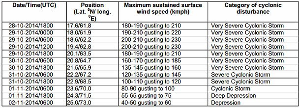
Nilofar is expected to make landfall with a tropical storm intensity on October 31, 2014. It will bring damaging winds, coastal flooding and life-threatening flooding due to heavy rain as it moves inland across southeast Pakistan and northwest India.
Cyclone Nilofar became the third strongest tropical cyclone on record in the Arabian Sea. According to Joint Typhoon Warning Center, Nilofar shortly reached equivalent of a Category 4 hurricane with estimated maximum sustained wind speeds of 210 km/h (130 mph).

This animation shows Cyclone Nilofar gathering strength in the Arabian Sea. The satellite imagery comes from MT-SAT and Meteosat-7, between 00:00 UTC on 25.10.2014 and 14:00 UTC on 27.10.2014 and is composed of infrared radiances overlaying NASA's Blue Marble Next Generation.
Nilofar will continue on a northwest track before taking a turn toward the north and then east-northeast across the northern Arabian Sea toward the coasts of southeastern Pakistan and the Indian province of Gujarat. The India Meteorological Department (IMD) has issued a yellow message cyclone alert for the northern coast of India's Gujarat state.
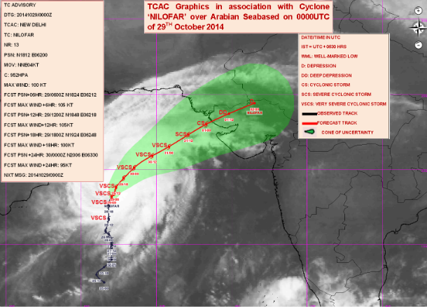
Cyclone Nilofar forecast track (Credit: IMD/RMSC New Delhi)
Forecast track and intensity of the system prediction table (Credit: India Meteorology Department)
.png)
TC Nilofar forecast track (Credit: JTWC)
Satellite animations
- Storm-Centered Infrared (Meteosat 7; CIMSS)
- Storm-Centered Enhanced Infrared (Meteosat 7; CIMSS)
- Storm-Centered Water Vapor (Meteosat 7; CIMSS)
- Storm-Centered Visible (Meteosat 7; CIMSS)
- Meteosat 7 Infrared
- Meteosat 7 Infrared (Color Background)
- Meteosat 7 Infrared (NHC Color Enhancement)
- Meteosat 7 Water Vapor
- Meteosat 7 Water Vapor (Color Background)
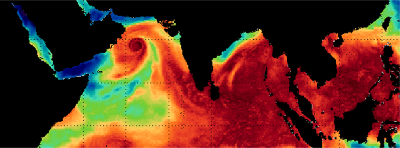
Featured image: MIMIC-TPW satellite image (Credit: SSEC/CIMSS)
Commenting rules and guidelines
We value the thoughts and opinions of our readers and welcome healthy discussions on our website. In order to maintain a respectful and positive community, we ask that all commenters follow these rules.