Tropical cyclones “Eunice” and “Diamondra” form over Indian Ocean
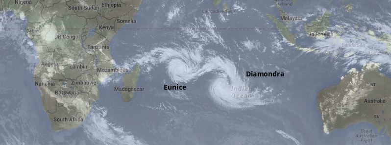
Two tropical cyclones have formed over Indian Ocean during last 48 hours. The first one formed on January 26 and was named Diamondra yesterday. The second one was named Eunice today.
Diamondra is far from land and is expected to stay there until it dissipates in the coming days.
On South-west Indian Ocean Tropical Cyclone intensity scale Diamondra has moderate tropical storm status. At 09:00 UTC yesterday, it had maximum sustained winds of 83.3 km/h (51.7 miles).
At the time, it was about 1 356 km (842 miles) SSE of Diego Garcia and was moving to the SSE at 11.1 km/h (6.9 mph).

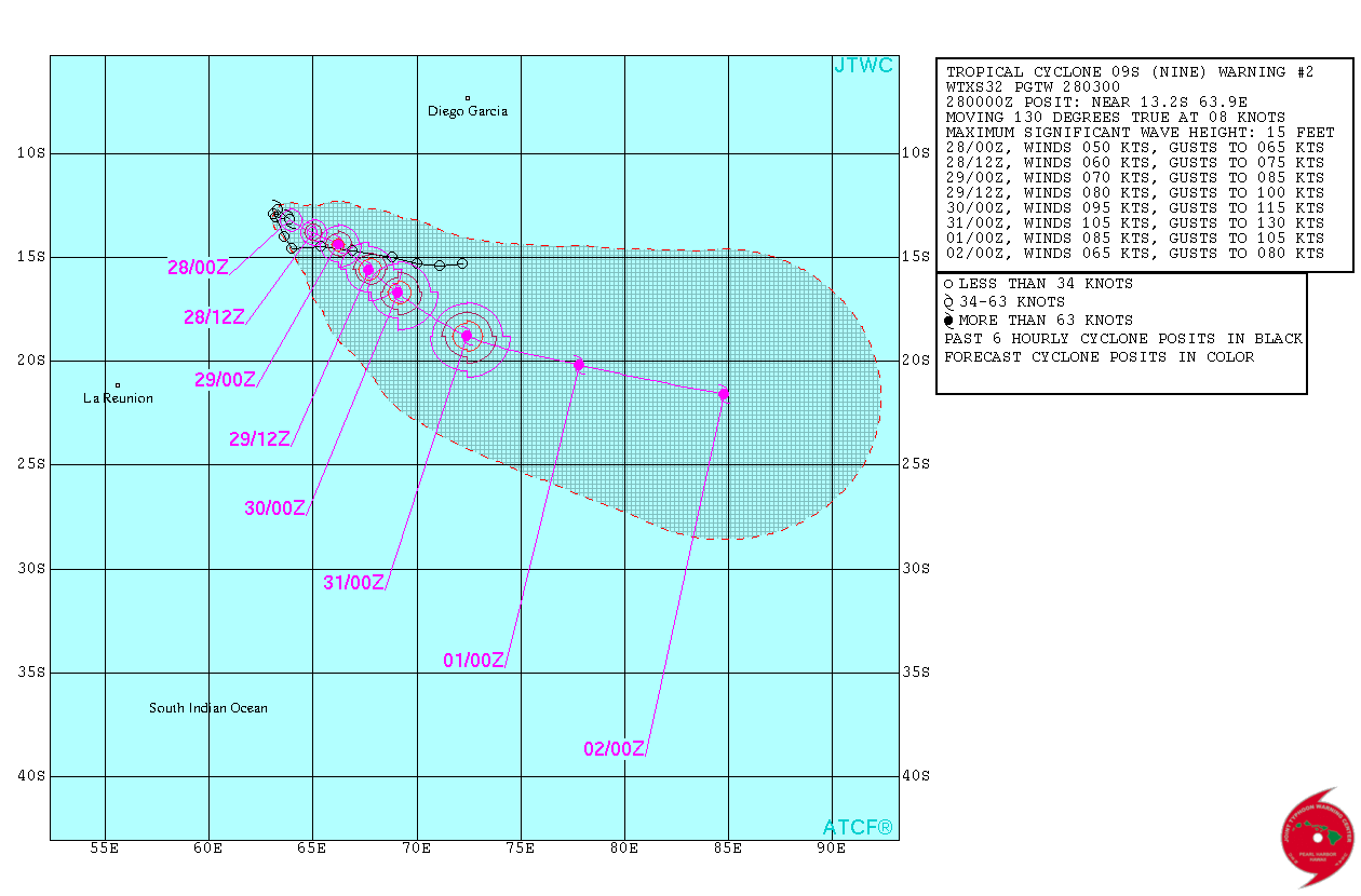
Diamondra forecast track by JTWC on January 28, 2015
According to the Tropical Cyclone Warning issued by RSMC La Reunion at 12:00 UTC yesterday, environmental conditions are conductive for further intensification up to Wednesday, experiencing an efficient low levels inflows on the both sides, a weak to moderate vertical wind shear and a good divergence eastward under the upper level ridge.
On Wednesday, the westerly vws increase should limit the development.
Tropical Rainfall Measuring Mission (TRMM) flew over Diamondra on January 27 at 14:02 UTC and measured rainfall rates within the storm. TRMM found heavy rainfall occurring east of the center of circulation in excess of 4 cm (1.6 inches) per hour.

Image credit: NASA/JAXA/NRL/ESA
As of 06:00 UTC today, Diamondra had central pressure of 988 hPa and maximum average (10 minute) wind speed of 83.3 km/h (51.7 mph). The system is expected to track globally to the SE under the steering influence of near-equatorial ridge and a transient mid-level trough in its south.
It is not expected to weaken rapidly and it is not excluded that a temporarily strengthening could occur within the next 24 hours.
From Saturday, Diamondra should begin its extra-tropicalization.

Image credit: METEO France / RSMC La Reunion
Tropical Cyclone "Eunice" formed west of Diamondra yesterday and is expected to rapidly intensify. At 03:00 UTC today it was located 1 159 km SW of Diego Garcia and was moving SE at 14.8 km/h (9.2 mph).
At 06:00 UTC, Eunice was a severe tropical storm on the South-west Indian Ocean Tropical Cyclone intensity scale.
At the time, its central pressure was 985 hPa. Maximum average (10 minute) wind speed was 101 km/h (63.2 mph).
Eunice forecast track by JTWC on January 28, 2015
Eunice continues to show some evident signs of intensification and a ragged eye is now apparent on the very last images. The system is expected to track ESE.
On this forecast track, environmental conditions are expected to be more and more conductive for intensification.

Image credit: CIMSS / METEOSAT-7
Satellite animations for "Diamondra"
- Storm-Centered Infrared (Meteosat 7; NOAA/SSD)
- Storm-Centered Infrared (Aviation Color Enhancement) (Meteosat 7; NOAA/SSD)
- Storm-Centered Water Vapor (Meteosat 7; NOAA/SSD)
- Storm-Centered Visible (Meteosat 7; NOAA/SSD)
- Storm-Centered Visible (Colorized) (Meteosat 7; NOAA/SSD)
- Storm-Centered Infrared (Meteosat 7; CIMSS)
- Storm-Centered Enhanced Infrared (Meteosat 7; CIMSS)
- Storm-Centered Water Vapor (Meteosat 7; CIMSS)
- Storm-Centered Visible (Meteosat 7; CIMSS)
- Meteosat 7 Infrared (Meteosat 7; CIMSS)
- Meteosat 7 Infrared (Color Background) (Meteosat 7; CIMSS)
- Meteosat 7 Infrared (NHC Color Enhancement) (Meteosat 7; CIMSS)
- Meteosat 7 Water Vapor (Meteosat 7; CIMSS)
- Meteosat 7 Water Vapor (Color Background) (Meteosat 7; CIMSS)
Satellite animations for "Eunice"
- Storm-Centered Infrared (Meteosat 7; NOAA/SSD)
- Storm-Centered Infrared (Aviation Color Enhancement) (Meteosat 7; NOAA/SSD)
- Storm-Centered Water Vapor (Meteosat 7; NOAA/SSD)
- Storm-Centered Visible (Meteosat 7; NOAA/SSD)
- Storm-Centered Visible (Colorized) (Meteosat 7; NOAA/SSD)
- Storm-Centered Infrared (Meteosat 7; CIMSS)
- Storm-Centered Enhanced Infrared (Meteosat 7; CIMSS)
- Storm-Centered Water Vapor (Meteosat 7; CIMSS)
- Storm-Centered Visible (Meteosat 7; CIMSS)
- Meteosat 7 Infrared (Meteosat 7; CIMSS)
- Meteosat 7 Infrared (Color Background) (Meteosat 7; CIMSS)
- Meteosat 7 Infrared (NHC Color Enhancement) (Meteosat 7; CIMSS)
- Meteosat 7 Water Vapor (Meteosat 7; CIMSS)
- Meteosat 7 Water Vapor (Color Background) (Meteosat 7; CIMSS)
Featured image credit: UW CIMSS
Does these two cyclones have a hand in causing dangerous storms over land like places near the lake shores of Victoria? Today, we experienced a heavy storm within Buganda in Uganda but the cause is not known clearly so my question is what caused the storm yet before it occurring, the situation was green; showing no hazardous weather expected??
Thanks;
Best regards
Masiasi from Uganda.
No, those two systems definitely not.