Australian tropical cyclone season officially closes
The Australian 2014-15 tropical cyclone season has officially ended. Seven tropical cyclones formed or moved into the Australian region, with four making landfall on the Australian continent. Seven tropical cyclones in the Australian region is below the long-term average of eleven; however, four storms crossing the Australian coastline is equal to the long-term average for cyclones making landfall, Australian Bureau of Meteorology said today.
The first tropical cyclone to develop over Australian waters was tropical cyclone Kate. Kate developed over the eastern Indian Ocean on December 21, 2014, reaching category 4 before weakening over the ocean. The northern Australia monsoon onset occurred at Darwin shortly afterwards on December 31. The monsoon continued for the first two weeks of January. Although two lows formed within the monsoon trough during this period, neither storm strengthened to tropical cyclone strength.
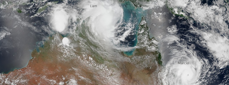
On February 20 two tropical cyclones, Lam and Marcia, made landfall over the Australian coast within hours of each other. Tropical cyclone Lam, which developed to tropical cyclone strength in the Gulf of Carpentaria, tracked slowly westwards, then crossed the coast near Milingimbi in the Northern Territory. Tropical Cyclone Marcia developed to tropical cyclone strength in the Coral Sea and crossed the coast near Yeppoon in Queensland. Both tropical cyclones caused significant damage to property.
Ex-Tropical Cyclone "Lam" and Tropical Cyclone "Marcia" at 10:00 UTC on February 20, 2015. Image credit: WMS/SSEC – University of Wisconsin -Madison
Almost a month later, in March, two other tropical cyclones formed and crossed the Australian coastline. Tropical cyclone Olwyn reached Western Australia on March 15 at category 3 strength, while tropical cyclone Nathan formed over the Coral Sea. Nathan was a long-lived system that crossed the Australian coastline three times in March: Cape York on the 2nd, Arnhem Land on the 22nd and the north coast near Milingimbi on the 24th.
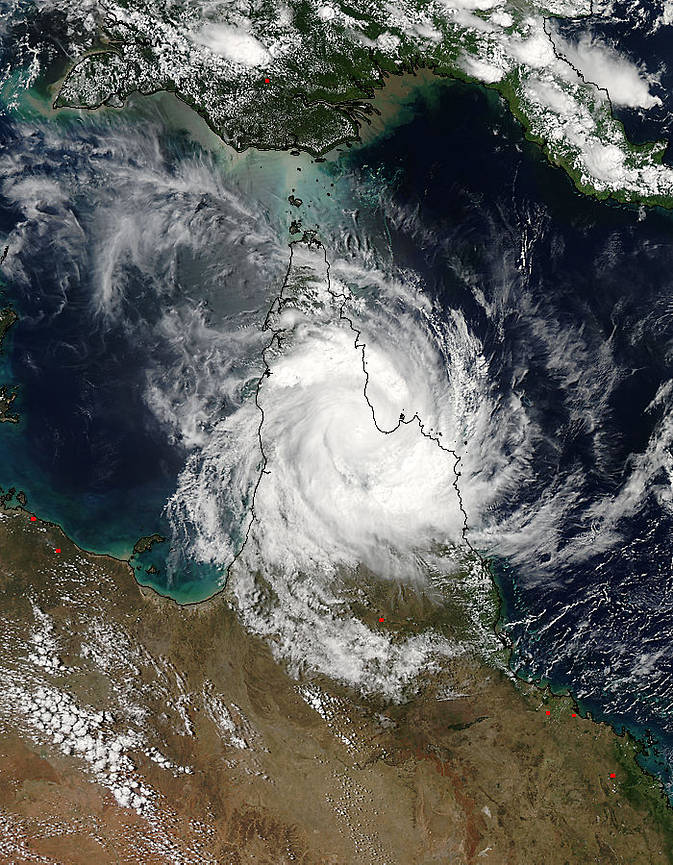
The MODIS instrument aboard NASA's Aqua satellite captured this image of Tropical Cyclone Nathan (18P) over Cape York Peninsula, Australia on March 20 at 04:05 UTC. Image credit: NASA Goddard MODIS Rapid Response Team.
In the first week of April tropical cyclone Ikola moved into the Australian region, but did not make landfall. The final storm to form in the Australian area was tropical cyclone Quang, which formed off the northwest coast on April 28 and crossed the coast as a tropical low on 1 May.
See the Bureau's MJO Monitoring for current MJO information.
El Nino in 2015 remains likely
Based on model outlooks and current observations, the Bureau assesses the likelihood of El Niño developing in the coming months to be at least a 70% chance. El Niño is often associated with below–average rainfall over eastern Australia during the second half of the year.
All climate indicators show signs of a developing El Niño. The sea surface temperature anomaly in the NINO3.4 region has warmed to +1.1 °C, a value consistent with El Niño, if warming persists. Cloudiness near the dateline has been below average for two consecutive months and trade winds along the equator are weaker than normal. The Southern Oscillation Index for April is −3.8.
See the Bureau of Meteorology's ENSO Wrap-Up for official El Niño information.
Source: Australian Bureau of Meteorology
Featured image: Tropical Cyclones "Lam" and "Marcia" on February 19, 2015. Image credit: SUOMI NPP – VIIRS.
Commenting rules and guidelines
We value the thoughts and opinions of our readers and welcome healthy discussions on our website. In order to maintain a respectful and positive community, we ask that all commenters follow these rules.