Typhoon “In-Fa” to become violent while passing Guam
Tropical Storm "In-Fa" transitioned into a very strong typhoon on November 18, 2015, according to the Joint Typhoon Warning Center (JTWC). The system is still intensifying and is expected to become of violent strength as it passes south of Guam on November 21. Guam residents have been placed on high alert and urged to remain indoors as dangerous weather conditions are expected.
The low pressure area in the northwest Pacific formed into a Tropical Depression "27W" on November 17, and intensified into a tropical storm only a few hours later. In-Fa is currently a full-blown, very strong typhoon approaching Guam at relatively fast pace.
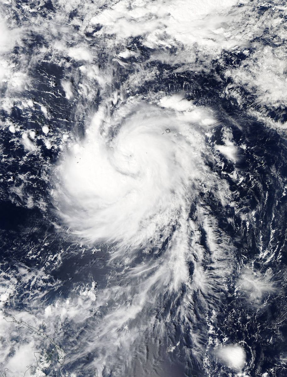
The MODIS instrument aboard NASA's Aqua satellite captured this visible image of Typhoon "In-fa" in the Pacific Ocean, November 18, 03:00 UTC. Image credit:NASA Goddard MODIS Rapid Response
As it transitioned into a typhoon, In-Fa rounded the 2015 season, calling it the first year where every month produced a typhoon in the Western Pacific Ocean: " Interesting fact with In-fa. With it being named a Typhoon by JTWC it makes 2015 the first time we had a typhoon every month from January to February in the Western Pacific,"Robert Speta, Westpacwx meteorologist said.
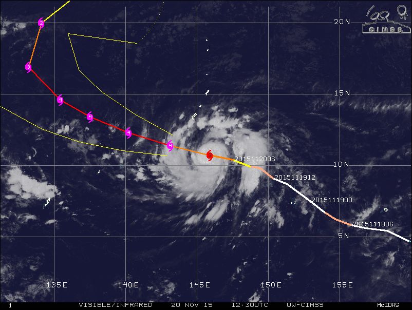
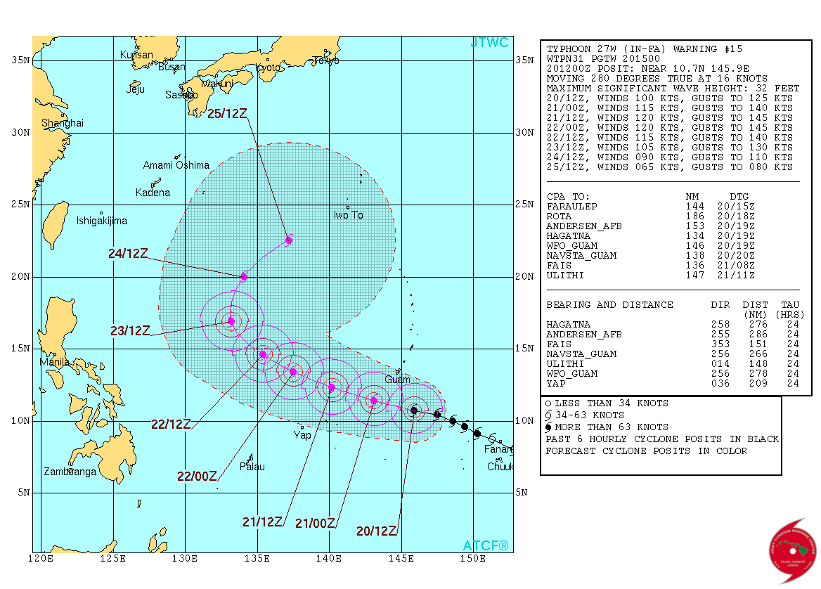
Typhoon "In-Fa" approaching Guam, November 20, 12:30 UTC. Image credit: UW-CIMSS
Typhoon "In-Fa" was located approximately 463 km (287.7 miles) southeast of Andersen Air Force Base, Guam, and moving west-northwestward at 22.2 km/h (13.8 mph) on November 20 at 09:00 UTC, according to JTWC. The system was packing maximum sustained winds of 185.2 km/h (115 mph) with gusts reaching 231.5 km/h (143.8 mph) at the time. Minimum central pressure was estimated at 948 hPa.
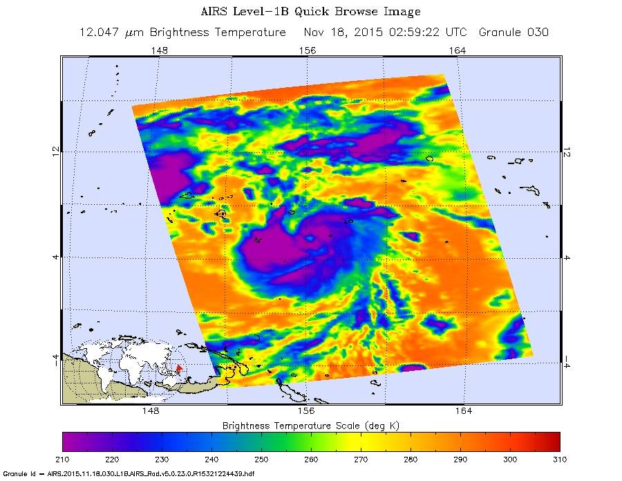
The AIRS instrument aboard NASA's Aqua satellite captured this infrared image of Typhoon "In-fa" that showed its 10 nautical-mile-wide eye, November 18, 02:59 UTC. Image credit: NASA JPL/Ed Olsen
In-fa will continue traveling west-northwestward over the next 72 hours intensifying. In the next 24 hours the system's strength is expected to peak, thus becoming a violent typhoon, with maximum sustained winds reaching 222.2 km/h (138 mph) and gusts up to 268.5 km/h (166.8 mph).

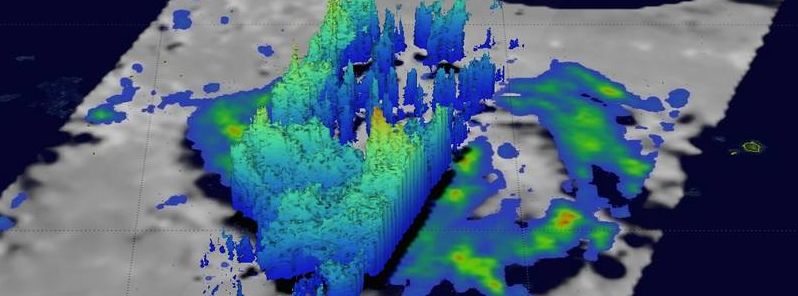
NASA/JAXA's GPM saw In-fa's storm top heights reaching heights of up to 16.7 km (10.4 miles) in convective storms within a feeder band to the west of the eye. Video credit: NASA/JAXA/SSAI, Hal Pierce
Over the next two days In-Fa will gradually weaken as ti starts to move polewards, in response to an approaching midlatitude trough. The system will interact with the baroclinic zone and the strong westerlies thus becoming extra-tropical over the next few days.
Typhoon "In-Fa" 5-day forecast track. Image credit: JTWC
Typhoon "In-Fa" is expected to pass south of Guam on the morning of November 21. Tropical storm warning has been issued for Guam, urging its residents to stay indoors and remain on high alert. Residents of the rest of the Mariana Islands are encouraged to closely monitor the situation, as well.
Featured image: NASA/JAXA's GPM saw In-fa's storm top heights reaching heights of up to 16.7 km (10.4 miles) in convective storms within a feeder band to the west of the eye. Image credit: NASA/JAXA/SSAI, Hal Pierce
Commenting rules and guidelines
We value the thoughts and opinions of our readers and welcome healthy discussions on our website. In order to maintain a respectful and positive community, we ask that all commenters follow these rules.