Deadly typhoon “Melor” (Nona) batters Philippines in a series of landfalls

Typhoon "Melor", also known in the Philippines as Nona, made initial landfall over Bulusan, Sorsogon in southern Luzon at 16:00 local time on December 14, 2015, as a violent typhoon, equivalent to a Category 4 hurricane on the Saffir-Simpson wind scale. The area was hit by heavy downpours and violent winds, leaving behind 4 victims and numerous devastated homes. The system is currently weakening, however, more severe weather conditions are expected over the next 24 hours.
The system made a series of landfalls over the Philippines since December 14. Its weakening after the initial land contact has been followed by another intensification, resulting in another Category 4 strength landfall over Mindoro Island in the early hours of December 15 (local time).
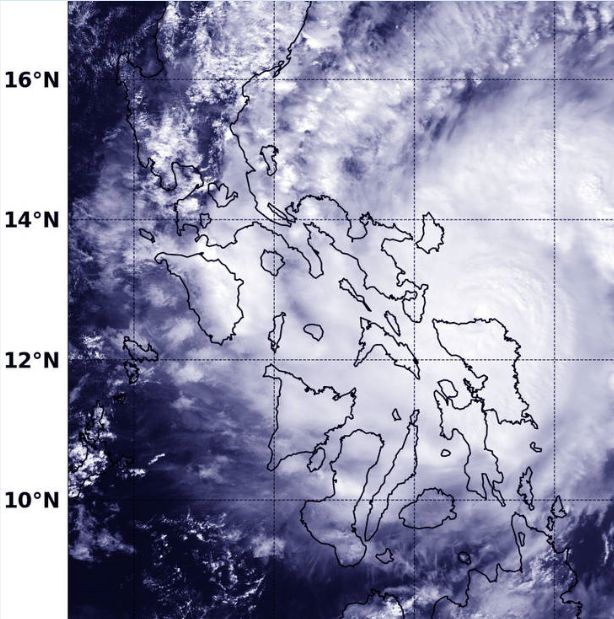
NASA-NOAA's Suomi NPP satellite captured this image of Melor on Dec. 14 at 05:43 UTC (12:43 a.m. EST) as it was making landfall in eastern Visayas, Philippines. Image credit: NASA/NOAA/Jeff Schmaltz
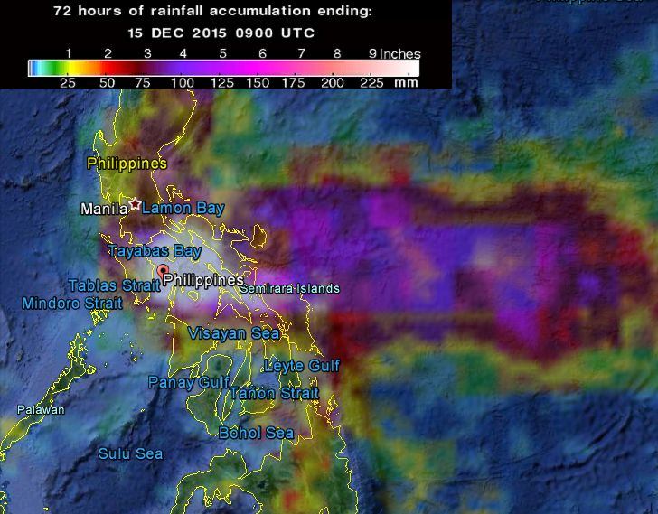
72-hr accumulation rainfall as observed by GPM Core Observatory. Image credit: Google/NASA/JAXA GPM
Melor battered the grounds of central Philippines with heavy rainfall and fierce winds. 4 people have been reported dead, so far, while 1 million islanders have been left without their power supplies across the region as violent winds toppled the trees and power poles.
The death toll might still rise as civil defense officials are doing their best to check the reports, battling the communication issues.
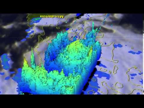
On December 14, the GPM satellite showed very intense storms in the southeastern side of Melor's eye wall were dropping rain at a rate of over 86 mm (3.4 inches) per hour. Storm top heights around Melor's eye were around 12.4 km (7.7 miles) and higher storm tops reaching 14.5 km (9 miles) were northeast of Melor's eye. Video credit: NASA/JAXA/SSAI/Hal Pierce
Over 200 mm (8 inches) of rain fell in only 12 hours in Calapan City on Mindoro Island on December 15. Masbate City measured a total of more than 175 mm (7 inches) of rainfall accumulation while Legazpi City reported 150 mm (6 inches) on December 14.
More than 730 000 people have been evacuated in the northern Visayas and southern Luzon ahead of the system's landfall, according to the Philippines Government. Schools and universities have been closed and flights canceled throughout the affected areas.
Video credit: The Straits Times
Winds of 160 km/h (100 mph) have been observed in northern Mindoro and southern Batangas provinces throughout the night of December 15 (local time).
"Melor is a very compact typhoon, so that will prevent its most devastating impacts from extending too far from its center," AccuWeather meteorologist Adam Douty said, as winds over 115 km/h (73 mph) extend only 45 km (30 miles) away from the typhoon's center.

Video credit: OneIndia News
According to the Philippine Atmospheric, Geophysical and Astronomical Services Administration (PAGASA), Melor's center was located over Santa Cruz, Occidental Mindoro at 16:00 local time on December 15. The system was packing maximum sustained winds of 140 km/h (86.9 mph) and gusts up to 170 km/h (105.6 mph).

Video credit: CCTV News
Public Storm Level Warning Signal of 3 is in effect across Oriental Mindoro and Occidental Mindoro, including Lubang Island, as winds between 121 and 170 km/h (75.2 and 105.6 mph) are expected over the next 18 hours. Wave heights in the open sea in the area could rise above 14 m (45.9 feet) while the storm surge may reach up to 3.6 m (11.8 feet).
Level Warning 2 was issued for areas of Batangas, Cavite, Marinduque, Romblon, and Calamian group of islands, where winds between 61 and 120 km/h (37.9 and 74.6 mph) are forecast within the next 24 hours. Storm surge is possible in coastal areas, while waves in the open sea can vary between 4.1 and 14 m (13.5 and 45.9 feet).
Dramatic videos on social media show Typhoon Melor hitting the Philippines https://t.co/LHQYQNr6VN pic.twitter.com/ubLX6EAXSI
— Mashable (@mashable) December 15, 2015
Level Warning 1 is in effect for Metro Manila, Bataan, Southern Zambales, Bulacan, Laguna, Rizal, Quezon and Northern Palawan including Cuyo Island, where wind speeds between 30 and 60 km/h (18.6 and 37.3 mph) are expected over the next 36 hours. Wave height in the open sea will vary between 1.25 and 4 m (4.1 and 13.1 feet).
Typhoon "Melor" will weaken by December 16, but strong wind gusts and heavy rainfall might still affect the region. Precipitation amount could reach 300 mm (12 inches) in the western Philippines, in particular in western Luzon where the higher terrain in combination with strong rains could pose a significant risk of deadly landslides.
Update, December 16, 2015:

Video courtesy of WestPacWx
Featured image: Violent typhoon "Melor" (Nona) hits the Philippines, December 15, 2015. Image credit: OneIndia News
Commenting rules and guidelines
We value the thoughts and opinions of our readers and welcome healthy discussions on our website. In order to maintain a respectful and positive community, we ask that all commenters follow these rules.