Very strong and shallow M6.9 earthquake hit near the coast of Vanuatu
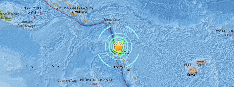
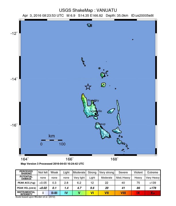
A very strong and shallow earthquake registered by the USGS as M6.9 (downgraded from M7.2) hit near the coast of Vanuatu at 08:23 UTC on April 3, 2016. The agency is reporting a depth of 35 km (21.7 miles). EMSC registered it as M7.0 at a depth of 40 km (24.8 miles).
According to the USGS, the epicenter was located 81 km (50 miles) NNW of Port-Olry, 136 km (85 miles) NNW of Luganville, 407 km (253 miles) NNW of Port-Vila, Vanuatu.
There are about 12 764 people living within 100 km (62 miles) radius.
Based on the preliminary earthquake parameters (M7.2 at a depth of 10 km (6.2 miles)), hazardous tsunami waves are possible for coasts located within 300 km (186 miles) of the earthquake epicenter, PTWC said.
ESTIMATED TIMES OF ARRIVAL
--------------------------

  * ESTIMATED TIMES OF ARRIVAL -ETA- OF THE INITIAL TSUNAMI WAVE
    FOR PLACES WITH A POTENTIAL TSUNAMI THREAT AS WELL AS FOR
    OTHER PLACES HAVING AN ETA WITHIN THE NEXT SIX HOURS. ACTUAL
    ARRIVAL TIMES MAY DIFFER AND THE INITIAL WAVE MAY NOT BE THE
    LARGEST. A TSUNAMI IS A SERIES OF WAVES AND THE TIME BETWEEN
    WAVES CAN BE FIVE MINUTES TO ONE HOUR.

    LOCATION         REGION             COORDINATES    ETA(UTC)
    ------------------------------------------------------------
    ESPERITU SANTO   VANUATU           15.1S 167.3E   0841 04/03
    SANTA CRUZ ISLA  SOLOMON ISLANDS   10.9S 165.9E   0911 04/03
    KIRAKIRA         SOLOMON ISLANDS   10.4S 161.9E   0921 04/03
    ANATOM ISLAND    VANUATU           20.2S 169.9E   0945 04/03
    AUKI             SOLOMON ISLANDS    8.8S 160.6E   0954 04/03
    HONIARA          SOLOMON ISLANDS    9.3S 160.0E   1004 04/03
    GHATERE          SOLOMON ISLANDS    7.8S 159.2E   1010 04/03
    MUNDA            SOLOMON ISLANDS    8.4S 157.2E   1022 04/03
    PANGGOE          SOLOMON ISLANDS    6.9S 157.2E   1024 04/03
    FALAMAE          SOLOMON ISLANDS    7.4S 155.6E   1025 04/03
    FUNAFUTI ISLAND  TUVALU             7.9S 178.5E   1037 04/03
    NAURU            NAURU              0.5S 166.9E   1040 04/03
    NOUMEA           NEW CALEDONIA     22.3S 166.5E   1040 04/03
    AMUN             PAPUA NEW GUINEA   6.0S 154.7E   1044 04/03
    WOODLARK ISLAND  PAPUA NEW GUINEA   9.0S 152.9E   1045 04/03
    KIETA            PAPUA NEW GUINEA   6.1S 155.6E   1045 04/03
    RABAUL           PAPUA NEW GUINEA   4.2S 152.3E   1103 04/03
    SUVA             FIJI              18.1S 178.4E   1108 04/03
    FUTUNA ISLAND    WALLIS AND FUTUN  14.3S 178.2W   1109 04/03
    WALLIS ISLAND    WALLIS AND FUTUN  13.3S 176.3W   1125 04/03
    KOSRAE ISLAND    KOSRAE             5.5N 163.0E   1135 04/03
    ULAMONA          PAPUA NEW GUINEA   5.0S 151.3E   1138 04/03
    LAE              PAPUA NEW GUINEA   6.8S 147.0E   1139 04/03
    HOWLAND ISLAND   HOWLAND AND BAKE   0.6N 176.6W   1143 04/03
    KAVIENG          PAPUA NEW GUINEA   2.5S 150.7E   1149 04/03
    RAOUL ISLAND     KERMADEC ISLANDS  29.2S 177.9W   1151 04/03
    NUKUNONU ISLAND  TOKELAU            9.2S 171.8W   1153 04/03
    MAJURO           MARSHALL ISLANDS   7.1N 171.4E   1157 04/03
    NORTH CAPE       NEW ZEALAND       34.4S 173.3E   1158 04/03
    NUKUALOFA        TONGA             21.0S 175.2W   1158 04/03
    PORT MORESBY     PAPUA NEW GUINEA   9.3S 146.9E   1200 04/03
    KWAJALEIN        MARSHALL ISLANDS   8.7N 167.7E   1202 04/03
    TARAWA ISLAND    KIRIBATI           1.5N 173.0E   1202 04/03
    KANTON ISLAND    KIRIBATI           2.8S 171.7W   1202 04/03
    APIA             SAMOA             13.8S 171.8W   1210 04/03
    POHNPEI ISLAND   POHNPEI            7.0N 158.2E   1211 04/03
    MADANG           PAPUA NEW GUINEA   5.2S 145.8E   1211 04/03
    BRISBANE         AUSTRALIA         27.2S 153.3E   1213 04/03
    PAGO PAGO        AMERICAN SAMOA    14.3S 170.7W   1214 04/03
    MANUS ISLAND     PAPUA NEW GUINEA   2.0S 147.5E   1222 04/03
    NIUE ISLAND      NIUE              19.0S 170.0W   1236 04/03
    CAIRNS           AUSTRALIA         16.7S 145.8E   1238 04/03
    ENIWETOK         MARSHALL ISLANDS  11.4N 162.3E   1244 04/03
    PUKAPUKA ISLAND  COOK ISLANDS      10.8S 165.9W   1246 04/03
    WEWAK            PAPUA NEW GUINEA   3.5S 143.6E   1250 04/03
    SYDNEY           AUSTRALIA         33.9S 151.4E   1253 04/03
    AUCKLAND WEST    NEW ZEALAND       37.1S 174.2E   1258 04/03
    VANIMO           PAPUA NEW GUINEA   2.6S 141.3E   1311 04/03
    CHUUK ISLAND     CHUUK              7.4N 151.8E   1313 04/03
    JAYAPURA         INDONESIA          2.4S 140.8E   1315 04/03
    GISBORNE         NEW ZEALAND       38.7S 178.0E   1318 04/03
    EAST CAPE        NEW ZEALAND       37.7S 178.5E   1323 04/03
    WAKE ISLAND      WAKE ISLAND       19.3N 166.6E   1328 04/03
    GLADSTONE        AUSTRALIA         23.8S 151.4E   1333 04/03
    JARVIS ISLAND    JARVIS ISLAND      0.4S 160.1W   1337 04/03
    NEW PLYMOUTH     NEW ZEALAND       39.1S 174.1E   1339 04/03
    AUCKLAND EAST    NEW ZEALAND       36.7S 175.0E   1343 04/03
    PALMYRA ISLAND   PALMYRA ISLAND     5.9N 162.1W   1345 04/03
    RAROTONGA        COOK ISLANDS      21.2S 159.8W   1352 04/03
    NAPIER           NEW ZEALAND       39.5S 176.9E   1354 04/03
    PENRYN ISLAND    COOK ISLANDS       8.9S 157.8W   1354 04/03
    MILFORD SOUND    NEW ZEALAND       44.6S 167.9E   1358 04/03
    JOHNSTON ISLAND  JOHNSTON ISLAND   16.7N 169.5W   1359 04/03
    GUAM             GUAM              13.4N 144.7E   1401 04/03
    WARSA            INDONESIA          0.6S 135.8E   1402 04/03
    SAIPAN           NORTHERN MARIANA  15.3N 145.8E   1406 04/03
    CHRISTMAS ISLAN  KIRIBATI           2.0N 157.5W   1407 04/03
    YAP ISLAND       YAP                9.5N 138.1E   1415 04/03
    WELLINGTON       NEW ZEALAND       41.3S 174.8E   1415 04/03
    MALDEN ISLAND    KIRIBATI           3.9S 154.9W   1415 04/03
    WESTPORT         NEW ZEALAND       41.8S 171.6E   1420 04/03
    MANOKWARI        INDONESIA          0.8S 134.2E   1421 04/03
    MINAMITORISHIMA  MINAMITORISHIMA   24.3N 154.0E   1421 04/03
    HOBART           AUSTRALIA         43.3S 147.6E   1428 04/03
USGS issued a green alert for shaking-related fatalities and economic losses. There is a low likelihood of casualties and damage. Overall, the population in this region resides in structures that are vulnerable to earthquake shaking, though some resistant structures exist.
Recent earthquakes in this area have caused secondary hazards such as tsunamis and landslides that might have contributed to losses.
Seismotectonics of the Eastern Margin of the Australia Plate
The eastern margin of the Australia plate is one of the most sesimically active areas of the world due to high rates of convergence between the Australia and Pacific plates. In the region of New Zealand, the 3000 km long Australia-Pacific plate boundary extends from south of Macquarie Island to the southern Kermadec Island chain. It includes an oceanic transform (the Macquarie Ridge), two oppositely verging subduction zones (Puysegur and Hikurangi), and a transpressive continental transform, the Alpine Fault through South Island, New Zealand.
Since 1900 there have been 15 M7.5+ earthquakes recorded near New Zealand. Nine of these, and the four largest, occurred along or near the Macquarie Ridge, including the 1989 M8.2 event on the ridge itself, and the 2004 M8.1 event 200 km to the west of the plate boundary, reflecting intraplate deformation. The largest recorded earthquake in New Zealand itself was the 1931 M7.8 Hawke's Bay earthquake, which killed 256 people. The last M7.5+ earthquake along the Alpine Fault was 170 years ago; studies of the faults' strain accumulation suggest that similar events are likely to occur again.
North of New Zealand, the Australia-Pacific boundary stretches east of Tonga and Fiji to 250 km south of Samoa. For 2,200 km the trench is approximately linear, and includes two segments where old (>120 Myr) Pacific oceanic lithosphere rapidly subducts westward (Kermadec and Tonga). At the northern end of the Tonga trench, the boundary curves sharply westward and changes along a 700 km-long segment from trench-normal subduction, to oblique subduction, to a left lateral transform-like structure.
Australia-Pacific convergence rates increase northward from 60 mm/yr at the southern Kermadec trench to 90 mm/yr at the northern Tonga trench; however, significant back arc extension (or equivalently, slab rollback) causes the consumption rate of subducting Pacific lithosphere to be much faster. The spreading rate in the Havre trough, west of the Kermadec trench, increases northward from 8 to 20 mm/yr. The southern tip of this spreading center is propagating into the North Island of New Zealand, rifting it apart. In the southern Lau Basin, west of the Tonga trench, the spreading rate increases northward from 60 to 90 mm/yr, and in the northern Lau Basin, multiple spreading centers result in an extension rate as high as 160 mm/yr. The overall subduction velocity of the Pacific plate is the vector sum of Australia-Pacific velocity and back arc spreading velocity: thus it increases northward along the Kermadec trench from 70 to 100 mm/yr, and along the Tonga trench from 150 to 240 mm/yr.
The Kermadec-Tonga subduction zone generates many large earthquakes on the interface between the descending Pacific and overriding Australia plates, within the two plates themselves and, less frequently, near the outer rise of the Pacific plate east of the trench. Since 1900, 40 M7.5+ earthquakes have been recorded, mostly north of 30°S. However, it is unclear whether any of the few historic M8+ events that have occurred close to the plate boundary were underthrusting events on the plate interface, or were intraplate earthquakes. On September 29, 2009, one of the largest normal fault (outer rise) earthquakes ever recorded (M8.1) occurred south of Samoa, 40 km east of the Tonga trench, generating a tsunami that killed at least 180 people.
Across the North Fiji Basin and to the west of the Vanuatu Islands, the Australia plate again subducts eastwards beneath the Pacific, at the North New Hebrides trench. At the southern end of this trench, east of the Loyalty Islands, the plate boundary curves east into an oceanic transform-like structure analogous to the one north of Tonga.
Australia-Pacific convergence rates increase northward from 80 to 90 mm/yr along the North New Hebrides trench, but the Australia plate consumption rate is increased by extension in the back arc and in the North Fiji Basin. Back arc spreading occurs at a rate of 50 mm/yr along most of the subduction zone, except near ~15°S, where the D'Entrecasteaux ridge intersects the trench and causes localized compression of 50 mm/yr in the back arc. Therefore, the Australia plate subduction velocity ranges from 120 mm/yr at the southern end of the North New Hebrides trench, to 40 mm/yr at the D'Entrecasteaux ridge-trench intersection, to 170 mm/yr at the northern end of the trench.
Large earthquakes are common along the North New Hebrides trench and have mechanisms associated with subduction tectonics, though occasional strike slip earthquakes occur near the subduction of the D'Entrecasteaux ridge. Within the subduction zone 34 M7.5+ earthquakes have been recorded since 1900. On October 7, 2009, a large interplate thrust fault earthquake (M7.6) in the northern North New Hebrides subduction zone was followed 15 minutes later by an even larger interplate event (M7.8) 60 km to the north. It is likely that the first event triggered the second of the so-called earthquake "doublet". More information on regional seismicity and tectonics
Featured image credit: USGS
Commenting rules and guidelines
We value the thoughts and opinions of our readers and welcome healthy discussions on our website. In order to maintain a respectful and positive community, we ask that all commenters follow these rules.