Meranti: The strongest tropical cyclone of the year slams Philippines, Taiwan and China
After the eye of Super Typhoon "Meranti" passed right over the Philippines island of Itbayat in the Luzon Strait, Meranti lashed Taiwan with powerful winds and heavy rain, killing 1 person and injuring more than 40. It then continued west and made its final landfall in China near Xiamen. According to the JTWC, Meranti peaked at 305 km/h (190 mph) sustained winds on Tuesday, September 13, 2016. This tied it with Typhoon "Tip" as the second-strongest tropical cyclone in the northwest Pacific since 1970 and made it the strongest tropical cyclone so far in 2016, surpassing Winston which had winds of 285 km/h (180 mph) when it struck Fiji in February.
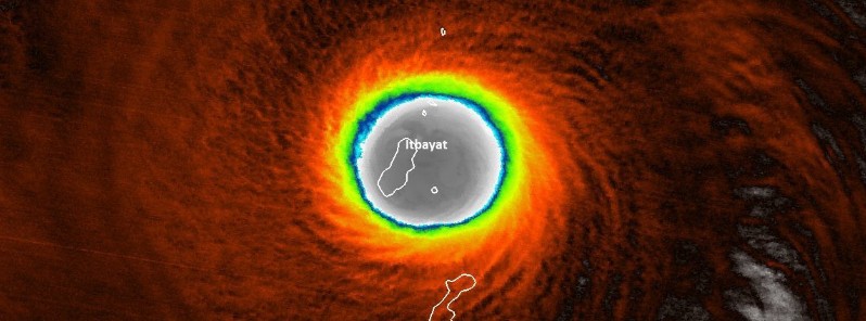
Meranti's eye passed right over the Philippines island of Itbayat (population 3 000) at 17:35 UTC on September 13. Communications with the island have been lost and as of 08:00 UTC on September 15, there is still no word on the fate of Itbayat's residents or the damage it made.
Pagasa's meteorological station in Manila reported yesterday that communications had not been established with Itbayat and that the local government was desperately trying to reach inhabitants. “Maybe we can fix communications by tomorrow,” a meteorologist there said, as strong gusts of wind were still being recorded in the area and night was falling. Residents, already familiar with strong typhoons, would hopefully have been protected by the traditional stone houses with strong, thick walls. “We pray there will be no casualties,” he said, as reported by The Guardian.
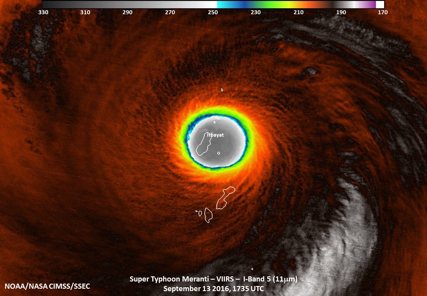
Credit: NASA/NOAA/DoD Suomi NPP/VIIRS, UW-CIMSS/SSEC
The JTWC upgraded Meranti to a super typhoon at 09:00 UTC on September 12, with 1-minute maximum sustained winds of 240 km/h (150 mph). Six hours later, the center estimated winds of 285 km/h (180 mph). A strong anticyclone over Meranti fueled the intensification, and the typhoon peaked in intensity at 305 km/h (190 mph) 1-minute sustained winds on September 13 while passing through the Luzon Strait. The JMA estimated peak 10-minute winds of 240 km/h (140 mph) and a minimum barometric pressure of 890 hPa, placing this typhoon among the most intense tropical cyclones ever.
Meranti passed just south of the southern tip of Taiwan around 00:00 UTC on September 14, bringing torrential rain and wind gusts up to 370 km/h (230 mph). Southern Kenting on the Hengchun Peninsula, located at the southern tip of Taiwan and known for its white-sand beaches, caves and coral reefs, was battered by powerful winds, heavy rain and floods.
According to Taiwan's Central Weather Bureau, Hengchun's observation station recorded the strongest gusts in its 120-year history.
A small lighthouse in a fishing port in southern Taitung county disappeared overnight. It is believed that powerful winds blew it into the sea, as waves almost 10 m (32.8 feet) high lashed the shore in that area. Many trucks were overturned and roofs blown off while electricity poles and trees were uprooted in some southern areas.
In the port city of Kaohsiung, at least 10 cargo ships broke from their anchors, including a 140 000-tonne vessel that rammed into two cargo cranes. Many cargo containers that were piled high in the port’s storage yards were blown off and scattered on the ground, local authorities said.
A spokeswoman for the Taiwan Red Cross said that one person has lost its life and 44 people were injured.
More than 900 000 households had lost power, while another 500 000 had issues with water supply, she said.
Meranti was the strongest typhoon to hit Taiwan in 21 years in terms of maximum sustained wind near the center. It brought more than 508 mm (20 inches) of rain to the island.

Video courtesy Victor Boulanger

Video courtesy ODN

Video courtesy CCTV
Meranti made its second landfall at around 19:05 UTC on September 14 over Xiang'an District, Xiamen in China's Fujian Province.
When it made landfall, Meranti's maximum sustained winds were 167 km/h (104 mph) and gusts to 204 km/h (127 mph), which made it a Category 2 hurricane equivalent on the Saffir-Simpson Hurricane Wind Scale.
Typhoon #Meranti making landfall in southeast #China with Category 2 intensity. pic.twitter.com/mEmggVPxWf
— UW-Madison CIMSS (@UWCIMSS) September 14, 2016
The storm prompted China to issue its highest warning for high ocean waves. Xinhua news agency said it was the strongest typhoon to hit that part of the country since the founding of Communist China in 1949.
The storm caused power cuts for 1.65 million homes. More than 1 million people are still without electricity, as of 10:00 UTC on September 15.

Video courtesy Al Jazeera
Dangerous winds, heavy rainfall and flash flooding are expected to continue until September 16.
Mudslides present a significant threat.
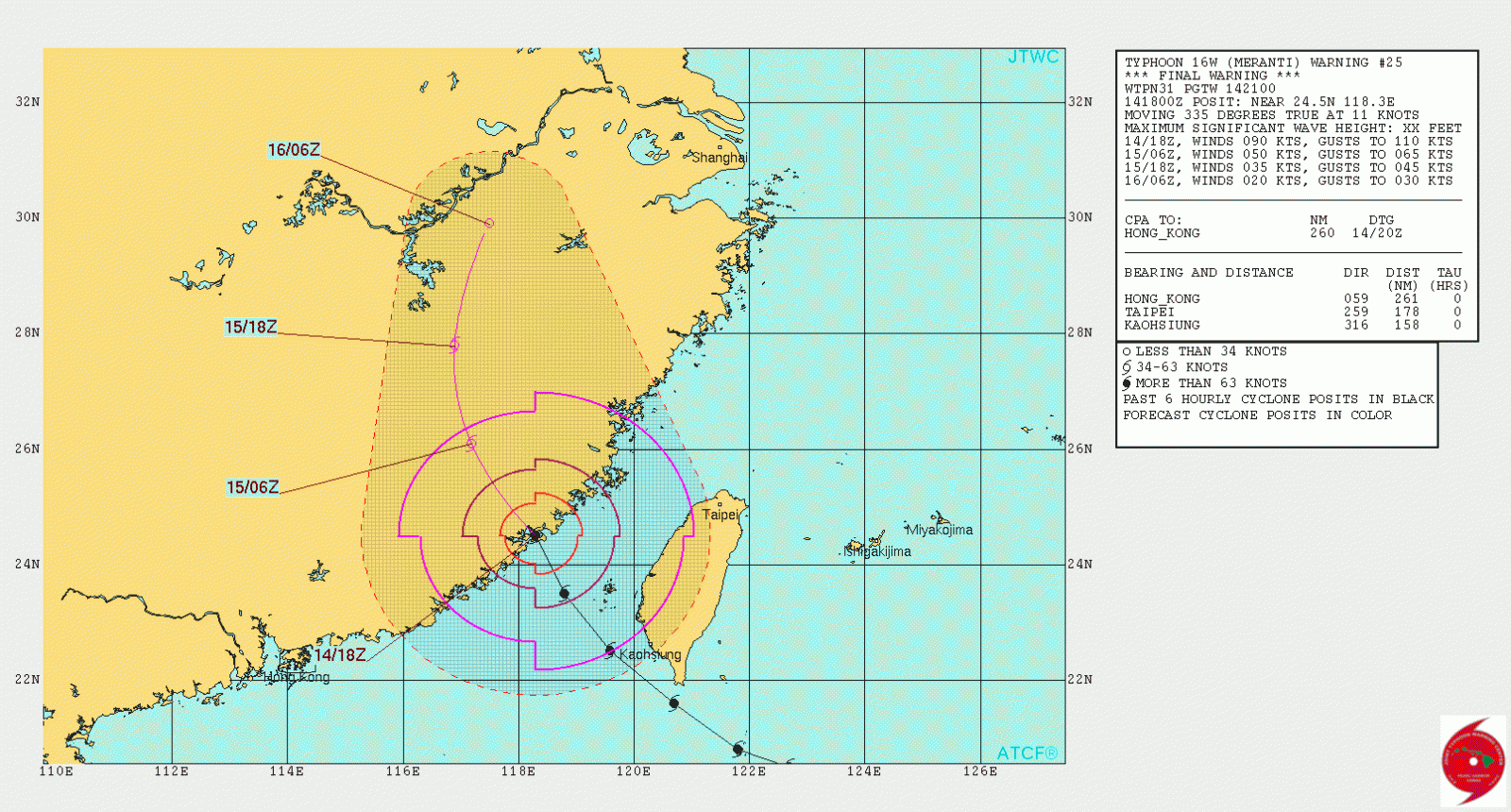
Typhoon "Meranti" forecast track at 18:00 UTC on September 14 by JTWC
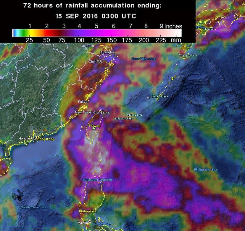
72 hours of rainfall accumulation ending 03:00 UTC on September 15, 2016. Credit: NASA/TRMM, Google
While all eyes were on Meranti, another tropical storm was born east of Guam on September 12. Its name is Malakas and it became a typhoon on September 14.
Malakas is expected to pass northwest of Luzon, Philippines today as a Category 2 hurricane equivalent. It will continue intensifying and pass with its center about 80 km (51 miles) NE off the northeastern tip of Taiwan at around 06:00 UTC on September 17 as a Category 3 hurricane equivalent.
After that, Malakas will be on its way toward Kyushu, Japan. JTWC's current forecast track takes it right over Kimotsuki, Kagoshima Prefecture before 00:00 UTC on September 20.
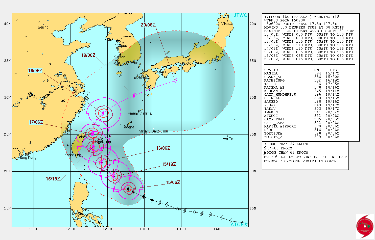
Typhoon "Malakas" forecast track by JTWC at 09:00 UTC on September 15, 2016
Update, September 16
At least 16 people have been killed, the government said Friday, September 16. Another 9 people are missing and more than 330 000 had been evacuated.
Flooding destroyed an 871-year-old bridge that was a protected heritage site in Yongchun county, Xinhua said.
Featured image: Super Typhoon "Meranti" over Itbayat, Philippines at 17:35 UTC on September 13, 2016. Credit: NOAA/NASA CIMSS/SSEC
Commenting rules and guidelines
We value the thoughts and opinions of our readers and welcome healthy discussions on our website. In order to maintain a respectful and positive community, we ask that all commenters follow these rules.